You are here: Home > Network List > TA - USArray Transportable Network (new EarthScope stations) Stations List
> Station Z23A Rita Site, White Sands Missle Range, NM, USA > Earthquake Result Viewer
Z23A Rita Site, White Sands Missle Range, NM, USA - Earthquake Result Viewer
| Earthquake location: |
North Of Svalbard |
| Earthquake latitude/longitude: |
80.3/-1.9 |
| Earthquake time(UTC): |
2009/03/06 (065) 10:50:29 GMT |
| Earthquake Depth: |
9.0 km |
| Earthquake Magnitude: |
6.6 MB, 6.5 MS, 6.5 MW, 6.4 MW |
| Earthquake Catalog/Contributor: |
WHDF/NEIC |
|
| Network: |
TA USArray Transportable Network (new EarthScope stations) |
| Station: |
Z23A Rita Site, White Sands Missle Range, NM, USA |
| Lat/Lon: |
33.26 N/106.23 W |
| Elevation: |
1278 m |
|
| Distance: |
59.8 deg |
| Az: |
290.126 deg |
| Baz: |
10.929 deg |
| Ray Param: |
0.06194452 |
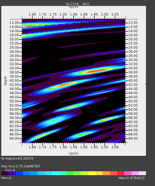
| Estimated Moho Depth: |
13.75 km |
| Estimated Crust Vp/Vs: |
1.60 |
| Assumed Crust Vp: |
6.502 km/s |
| Estimated Crust Vs: |
4.063 km/s |
| Estimated Crust Poisson's Ratio: |
0.18 |
|
| Radial Match: |
83.28278 % |
| Radial Bump: |
400 |
| Transverse Match: |
80.79648 % |
| Transverse Bump: |
400 |
| SOD ConfigId: |
2658 |
| Insert Time: |
2010-03-06 07:57:55.455 +0000 |
| GWidth: |
2.5 |
| Max Bumps: |
400 |
| Tol: |
0.001 |
|
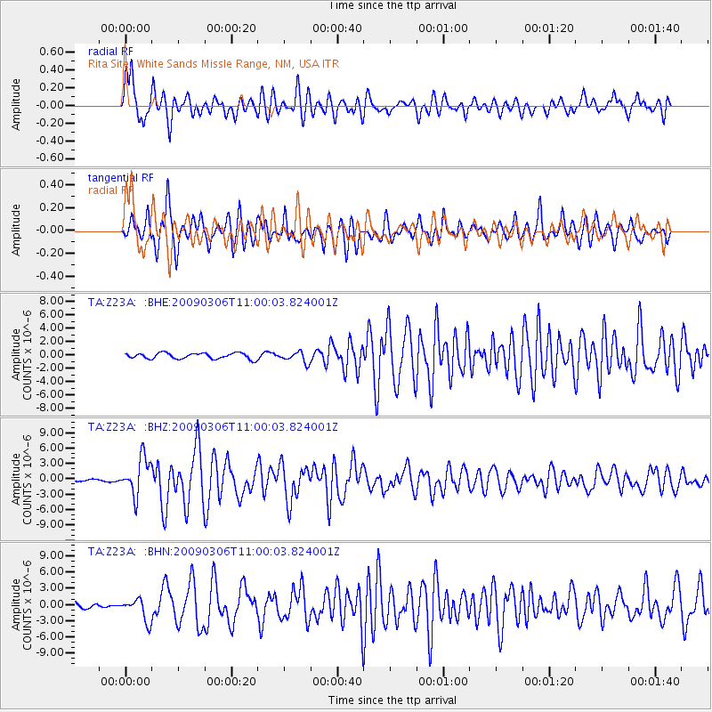
Signal To Noise
| Channel | StoN | STA | LTA |
| TA:Z23A: :BHZ:20090306T11:00:03.824001Z | 14.775578 | 3.687509E-6 | 2.4956785E-7 |
| TA:Z23A: :BHN:20090306T11:00:03.824001Z | 2.8216739 | 2.109504E-6 | 7.4760726E-7 |
| TA:Z23A: :BHE:20090306T11:00:03.824001Z | 1.8840433 | 8.1957666E-7 | 4.3500947E-7 |
| Arrivals |
| Ps | 1.3 SECOND |
| PpPs | 5.2 SECOND |
| PsPs/PpSs | 6.5 SECOND |


