You are here: Home > Network List > ZB17 - Rapid Aftershock Deployment for the September 2017 M=8.1 and M.7.1 Earthquakes i Stations List
> Station B05 Station B05, Mexico RAMP Oaxaca Experiment > Earthquake Result Viewer
B05 Station B05, Mexico RAMP Oaxaca Experiment - Earthquake Result Viewer
| Earthquake location: |
Near Coast Of Peru |
| Earthquake latitude/longitude: |
-15.8/-74.7 |
| Earthquake time(UTC): |
2018/01/14 (014) 09:18:45 GMT |
| Earthquake Depth: |
36 km |
| Earthquake Magnitude: |
7.1 mww |
| Earthquake Catalog/Contributor: |
NEIC PDE/us |
|
| Network: |
ZB Rapid Aftershock Deployment for the September 2017 M=8.1 and M.7.1 Earthquakes i |
| Station: |
B05 Station B05, Mexico RAMP Oaxaca Experiment |
| Lat/Lon: |
16.08 N/93.78 W |
| Elevation: |
69 m |
|
| Distance: |
36.8 deg |
| Az: |
328.437 deg |
| Baz: |
148.385 deg |
| Ray Param: |
0.07640559 |
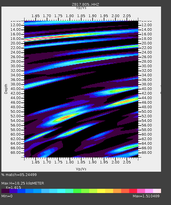
| Estimated Moho Depth: |
18.25 km |
| Estimated Crust Vp/Vs: |
1.62 |
| Assumed Crust Vp: |
6.438 km/s |
| Estimated Crust Vs: |
3.987 km/s |
| Estimated Crust Poisson's Ratio: |
0.19 |
|
| Radial Match: |
85.24499 % |
| Radial Bump: |
400 |
| Transverse Match: |
71.7595 % |
| Transverse Bump: |
400 |
| SOD ConfigId: |
13570011 |
| Insert Time: |
2019-04-29 13:47:08.526 +0000 |
| GWidth: |
2.5 |
| Max Bumps: |
400 |
| Tol: |
0.001 |
|

Signal To Noise
| Channel | StoN | STA | LTA |
| ZB:B05: :HHZ:20180114T09:25:19.385002Z | 7.234222 | 5.188364E-6 | 7.171972E-7 |
| ZB:B05: :HHN:20180114T09:25:19.385002Z | 4.723852 | 3.3898957E-6 | 7.1761264E-7 |
| ZB:B05: :HHE:20180114T09:25:19.385002Z | 3.2175565 | 2.3984935E-6 | 7.454395E-7 |
| Arrivals |
| Ps | 1.9 SECOND |
| PpPs | 6.8 SECOND |
| PsPs/PpSs | 8.7 SECOND |


