You are here: Home > Network List > CI - Caltech Regional Seismic Network Stations List
> Station IRM Iron Mountain Pumping Station, Eagle Mtn., CA, USA > Earthquake Result Viewer
IRM Iron Mountain Pumping Station, Eagle Mtn., CA, USA - Earthquake Result Viewer
| Earthquake location: |
Fiji Islands Region |
| Earthquake latitude/longitude: |
-19.9/-178.2 |
| Earthquake time(UTC): |
2006/01/02 (002) 22:13:40 GMT |
| Earthquake Depth: |
583 km |
| Earthquake Magnitude: |
6.5 MB, 7.2 MW, 7.1 MW |
| Earthquake Catalog/Contributor: |
WHDF/NEIC |
|
| Network: |
CI Caltech Regional Seismic Network |
| Station: |
IRM Iron Mountain Pumping Station, Eagle Mtn., CA, USA |
| Lat/Lon: |
34.16 N/115.15 W |
| Elevation: |
567 m |
|
| Distance: |
80.5 deg |
| Az: |
48.528 deg |
| Baz: |
238.226 deg |
| Ray Param: |
0.04643262 |
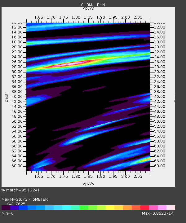
| Estimated Moho Depth: |
26.75 km |
| Estimated Crust Vp/Vs: |
1.76 |
| Assumed Crust Vp: |
6.276 km/s |
| Estimated Crust Vs: |
3.561 km/s |
| Estimated Crust Poisson's Ratio: |
0.26 |
|
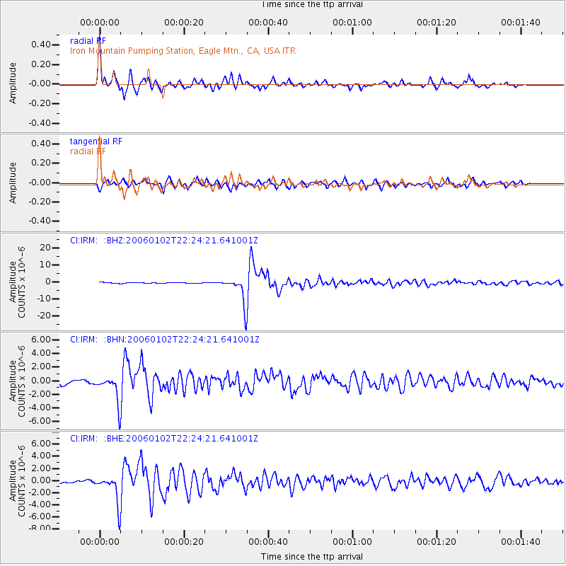
| Radial Match: |
95.12241 % |
| Radial Bump: |
342 |
| Transverse Match: |
89.79754 % |
| Transverse Bump: |
400 |
| SOD ConfigId: |
2422 |
| Insert Time: |
2010-02-26 01:43:57.167 +0000 |
| GWidth: |
2.5 |
| Max Bumps: |
400 |
| Tol: |
0.001 |
|
Signal To Noise
| Channel | StoN | STA | LTA |
| CI:IRM: :BHN:20060102T22:24:21.641001Z | 4.621288 | 2.0480659E-6 | 4.4318077E-7 |
| CI:IRM: :BHE:20060102T22:24:21.641001Z | 14.026436 | 2.4542157E-6 | 1.7497074E-7 |
| CI:IRM: :BHZ:20060102T22:24:21.641001Z | 35.038643 | 8.387951E-6 | 2.3939143E-7 |
| Arrivals |
| Ps | 3.3 SECOND |
| PpPs | 11 SECOND |
| PsPs/PpSs | 15 SECOND |


