You are here: Home > Network List > CN - Canadian National Seismograph Network Stations List
> Station INK INUVIK, NT > Earthquake Result Viewer
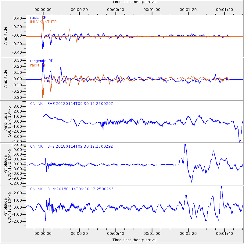
INK INUVIK, NT - Earthquake Result Viewer
*The percent match for this event was below the threshold and hence no stack was calculated.
| Earthquake location: |
Hindu Kush Region, Afghanistan |
| Earthquake latitude/longitude: |
36.5/70.7 |
| Earthquake time(UTC): |
2018/01/14 (014) 09:19:29 GMT |
| Earthquake Depth: |
200 km |
| Earthquake Magnitude: |
5.3 Mww |
| Earthquake Catalog/Contributor: |
NEIC PDE/us |
|
| Network: |
CN Canadian National Seismograph Network |
| Station: |
INK INUVIK, NT |
| Lat/Lon: |
68.31 N/133.53 W |
| Elevation: |
44 m |
|
| Distance: |
74.0 deg |
| Az: |
9.143 deg |
| Baz: |
339.843 deg |
| Ray Param: |
$rayparam |
*The percent match for this event was below the threshold and hence was not used in the summary stack. |
|
| Radial Match: |
84.64366 % |
| Radial Bump: |
400 |
| Transverse Match: |
75.56795 % |
| Transverse Bump: |
400 |
| SOD ConfigId: |
13570011 |
| Insert Time: |
2019-04-29 13:48:43.913 +0000 |
| GWidth: |
2.5 |
| Max Bumps: |
400 |
| Tol: |
0.001 |
|
Signal To Noise
| Channel | StoN | STA | LTA |
| CN:INK: :BHZ:20180114T09:30:12.250029Z | 2.1672168 | 1.3018507E-6 | 6.0070164E-7 |
| CN:INK: :BHN:20180114T09:30:12.250029Z | 1.4933171 | 5.8273787E-7 | 3.902305E-7 |
| CN:INK: :BHE:20180114T09:30:12.250029Z | 1.2150104 | 6.8927017E-7 | 5.672957E-7 |
| Arrivals |
| Ps | |
| PpPs | |
| PsPs/PpSs | |


