You are here: Home > Network List > TA - USArray Transportable Network (new EarthScope stations) Stations List
> Station Z23A Rita Site, White Sands Missle Range, NM, USA > Earthquake Result Viewer
Z23A Rita Site, White Sands Missle Range, NM, USA - Earthquake Result Viewer
*The percent match for this event was below the threshold and hence no stack was calculated.
| Earthquake location: |
Santiago Del Estero Prov., Arg. |
| Earthquake latitude/longitude: |
-26.7/-63.2 |
| Earthquake time(UTC): |
2008/09/03 (247) 11:25:14 GMT |
| Earthquake Depth: |
570 km |
| Earthquake Magnitude: |
5.9 MB, 6.3 MW, 6.3 MW |
| Earthquake Catalog/Contributor: |
WHDF/NEIC |
|
| Network: |
TA USArray Transportable Network (new EarthScope stations) |
| Station: |
Z23A Rita Site, White Sands Missle Range, NM, USA |
| Lat/Lon: |
33.26 N/106.23 W |
| Elevation: |
1278 m |
|
| Distance: |
72.3 deg |
| Az: |
323.144 deg |
| Baz: |
140.192 deg |
| Ray Param: |
$rayparam |
*The percent match for this event was below the threshold and hence was not used in the summary stack. |
|
| Radial Match: |
61.72499 % |
| Radial Bump: |
400 |
| Transverse Match: |
71.42026 % |
| Transverse Bump: |
400 |
| SOD ConfigId: |
2504 |
| Insert Time: |
2010-03-06 07:58:28.397 +0000 |
| GWidth: |
2.5 |
| Max Bumps: |
400 |
| Tol: |
0.001 |
|
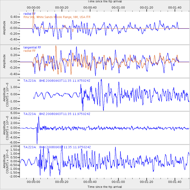
Signal To Noise
| Channel | StoN | STA | LTA |
| TA:Z23A: :BHZ:20080903T11:35:11.975024Z | 12.902448 | 1.8643452E-6 | 1.4449547E-7 |
| TA:Z23A: :BHN:20080903T11:35:11.975024Z | 2.4932516 | 5.077263E-7 | 2.0364023E-7 |
| TA:Z23A: :BHE:20080903T11:35:11.975024Z | 2.2016747 | 5.2937827E-7 | 2.4044348E-7 |
| Arrivals |
| Ps | |
| PpPs | |
| PsPs/PpSs | |


