You are here: Home > Network List > TA - USArray Transportable Network (new EarthScope stations) Stations List
> Station Z23A Rita Site, White Sands Missle Range, NM, USA > Earthquake Result Viewer
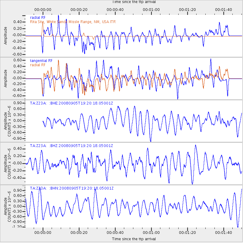
Z23A Rita Site, White Sands Missle Range, NM, USA - Earthquake Result Viewer
*The percent match for this event was below the threshold and hence no stack was calculated.
| Earthquake location: |
North Of Ascension Island |
| Earthquake latitude/longitude: |
-1.2/-14.0 |
| Earthquake time(UTC): |
2008/09/05 (249) 19:07:38 GMT |
| Earthquake Depth: |
10 km |
| Earthquake Magnitude: |
5.5 MB, 5.5 MS, 5.8 MW, 5.8 MW |
| Earthquake Catalog/Contributor: |
WHDF/NEIC |
|
| Network: |
TA USArray Transportable Network (new EarthScope stations) |
| Station: |
Z23A Rita Site, White Sands Missle Range, NM, USA |
| Lat/Lon: |
33.26 N/106.23 W |
| Elevation: |
1278 m |
|
| Distance: |
92.5 deg |
| Az: |
303.069 deg |
| Baz: |
89.732 deg |
| Ray Param: |
$rayparam |
*The percent match for this event was below the threshold and hence was not used in the summary stack. |
|
| Radial Match: |
53.542458 % |
| Radial Bump: |
400 |
| Transverse Match: |
44.011757 % |
| Transverse Bump: |
400 |
| SOD ConfigId: |
2560 |
| Insert Time: |
2010-03-06 07:58:29.332 +0000 |
| GWidth: |
2.5 |
| Max Bumps: |
400 |
| Tol: |
0.001 |
|
Signal To Noise
| Channel | StoN | STA | LTA |
| TA:Z23A: :BHZ:20080905T19:20:18.05001Z | 1.0357162 | 1.7094648E-7 | 1.6505146E-7 |
| TA:Z23A: :BHN:20080905T19:20:18.05001Z | 1.6570517 | 5.254106E-7 | 3.1707557E-7 |
| TA:Z23A: :BHE:20080905T19:20:18.05001Z | 1.0786338 | 2.1411844E-7 | 1.9850893E-7 |
| Arrivals |
| Ps | |
| PpPs | |
| PsPs/PpSs | |


