You are here: Home > Network List > TA - USArray Transportable Network (new EarthScope stations) Stations List
> Station B18K Kokolik River, AK, USA > Earthquake Result Viewer
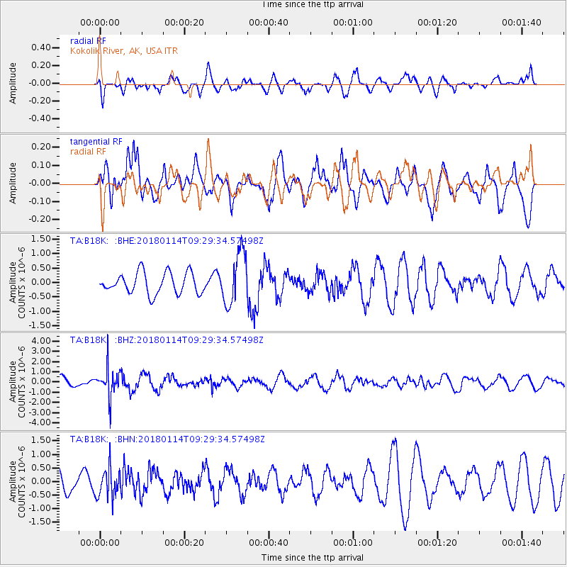
B18K Kokolik River, AK, USA - Earthquake Result Viewer
*The percent match for this event was below the threshold and hence no stack was calculated.
| Earthquake location: |
Hindu Kush Region, Afghanistan |
| Earthquake latitude/longitude: |
36.5/70.7 |
| Earthquake time(UTC): |
2018/01/14 (014) 09:19:29 GMT |
| Earthquake Depth: |
200 km |
| Earthquake Magnitude: |
5.3 Mww |
| Earthquake Catalog/Contributor: |
NEIC PDE/us |
|
| Network: |
TA USArray Transportable Network (new EarthScope stations) |
| Station: |
B18K Kokolik River, AK, USA |
| Lat/Lon: |
69.36 N/161.80 W |
| Elevation: |
222 m |
|
| Distance: |
67.7 deg |
| Az: |
17.704 deg |
| Baz: |
316.243 deg |
| Ray Param: |
$rayparam |
*The percent match for this event was below the threshold and hence was not used in the summary stack. |
|
| Radial Match: |
52.442944 % |
| Radial Bump: |
400 |
| Transverse Match: |
54.25408 % |
| Transverse Bump: |
400 |
| SOD ConfigId: |
13570011 |
| Insert Time: |
2019-04-29 13:50:48.813 +0000 |
| GWidth: |
2.5 |
| Max Bumps: |
400 |
| Tol: |
0.001 |
|
Signal To Noise
| Channel | StoN | STA | LTA |
| TA:B18K: :BHZ:20180114T09:29:34.57498Z | 3.11521 | 1.3930594E-6 | 4.471799E-7 |
| TA:B18K: :BHN:20180114T09:29:34.57498Z | 1.1502695 | 5.3144726E-7 | 4.6201978E-7 |
| TA:B18K: :BHE:20180114T09:29:34.57498Z | 2.5406733 | 9.2445094E-7 | 3.638606E-7 |
| Arrivals |
| Ps | |
| PpPs | |
| PsPs/PpSs | |


