You are here: Home > Network List > TA - USArray Transportable Network (new EarthScope stations) Stations List
> Station G31M Satah River, YT, CAN > Earthquake Result Viewer
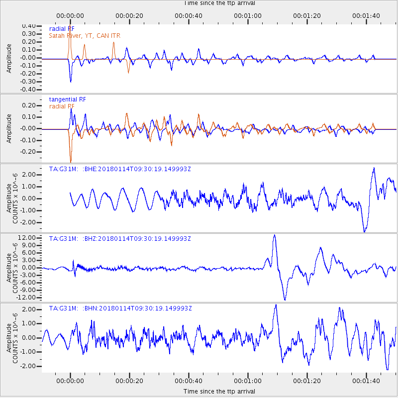
G31M Satah River, YT, CAN - Earthquake Result Viewer
*The percent match for this event was below the threshold and hence no stack was calculated.
| Earthquake location: |
Hindu Kush Region, Afghanistan |
| Earthquake latitude/longitude: |
36.5/70.7 |
| Earthquake time(UTC): |
2018/01/14 (014) 09:19:29 GMT |
| Earthquake Depth: |
200 km |
| Earthquake Magnitude: |
5.3 Mww |
| Earthquake Catalog/Contributor: |
NEIC PDE/us |
|
| Network: |
TA USArray Transportable Network (new EarthScope stations) |
| Station: |
G31M Satah River, YT, CAN |
| Lat/Lon: |
66.92 N/134.27 W |
| Elevation: |
61 m |
|
| Distance: |
75.2 deg |
| Az: |
9.924 deg |
| Baz: |
339.361 deg |
| Ray Param: |
$rayparam |
*The percent match for this event was below the threshold and hence was not used in the summary stack. |
|
| Radial Match: |
84.27762 % |
| Radial Bump: |
400 |
| Transverse Match: |
71.497345 % |
| Transverse Bump: |
400 |
| SOD ConfigId: |
13570011 |
| Insert Time: |
2019-04-29 13:51:16.267 +0000 |
| GWidth: |
2.5 |
| Max Bumps: |
400 |
| Tol: |
0.001 |
|
Signal To Noise
| Channel | StoN | STA | LTA |
| TA:G31M: :BHZ:20180114T09:30:19.149993Z | 3.2512438 | 1.1291852E-6 | 3.4730866E-7 |
| TA:G31M: :BHN:20180114T09:30:19.149993Z | 2.560334 | 6.3156665E-7 | 2.4667355E-7 |
| TA:G31M: :BHE:20180114T09:30:19.149993Z | 0.78949195 | 4.3734497E-7 | 5.5395753E-7 |
| Arrivals |
| Ps | |
| PpPs | |
| PsPs/PpSs | |


