You are here: Home > Network List > TA - USArray Transportable Network (new EarthScope stations) Stations List
> Station I23K Minto, Yukon-Koyukuk, AK, USA > Earthquake Result Viewer
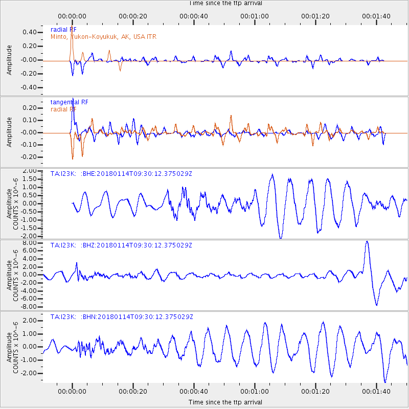
I23K Minto, Yukon-Koyukuk, AK, USA - Earthquake Result Viewer
*The percent match for this event was below the threshold and hence no stack was calculated.
| Earthquake location: |
Hindu Kush Region, Afghanistan |
| Earthquake latitude/longitude: |
36.5/70.7 |
| Earthquake time(UTC): |
2018/01/14 (014) 09:19:29 GMT |
| Earthquake Depth: |
200 km |
| Earthquake Magnitude: |
5.3 Mww |
| Earthquake Catalog/Contributor: |
NEIC PDE/us |
|
| Network: |
TA USArray Transportable Network (new EarthScope stations) |
| Station: |
I23K Minto, Yukon-Koyukuk, AK, USA |
| Lat/Lon: |
65.15 N/149.36 W |
| Elevation: |
149 m |
|
| Distance: |
74.0 deg |
| Az: |
16.446 deg |
| Baz: |
327.307 deg |
| Ray Param: |
$rayparam |
*The percent match for this event was below the threshold and hence was not used in the summary stack. |
|
| Radial Match: |
38.350468 % |
| Radial Bump: |
282 |
| Transverse Match: |
47.789745 % |
| Transverse Bump: |
391 |
| SOD ConfigId: |
13570011 |
| Insert Time: |
2019-04-29 13:51:23.019 +0000 |
| GWidth: |
2.5 |
| Max Bumps: |
400 |
| Tol: |
0.001 |
|
Signal To Noise
| Channel | StoN | STA | LTA |
| TA:I23K: :BHZ:20180114T09:30:12.375029Z | 1.5434144 | 1.0852651E-6 | 7.0315866E-7 |
| TA:I23K: :BHN:20180114T09:30:12.375029Z | 0.46719587 | 2.6686533E-7 | 5.7120656E-7 |
| TA:I23K: :BHE:20180114T09:30:12.375029Z | 1.1939768 | 5.106336E-7 | 4.2767465E-7 |
| Arrivals |
| Ps | |
| PpPs | |
| PsPs/PpSs | |


