You are here: Home > Network List > TA - USArray Transportable Network (new EarthScope stations) Stations List
> Station P17K Kvichak River, AK, USA > Earthquake Result Viewer
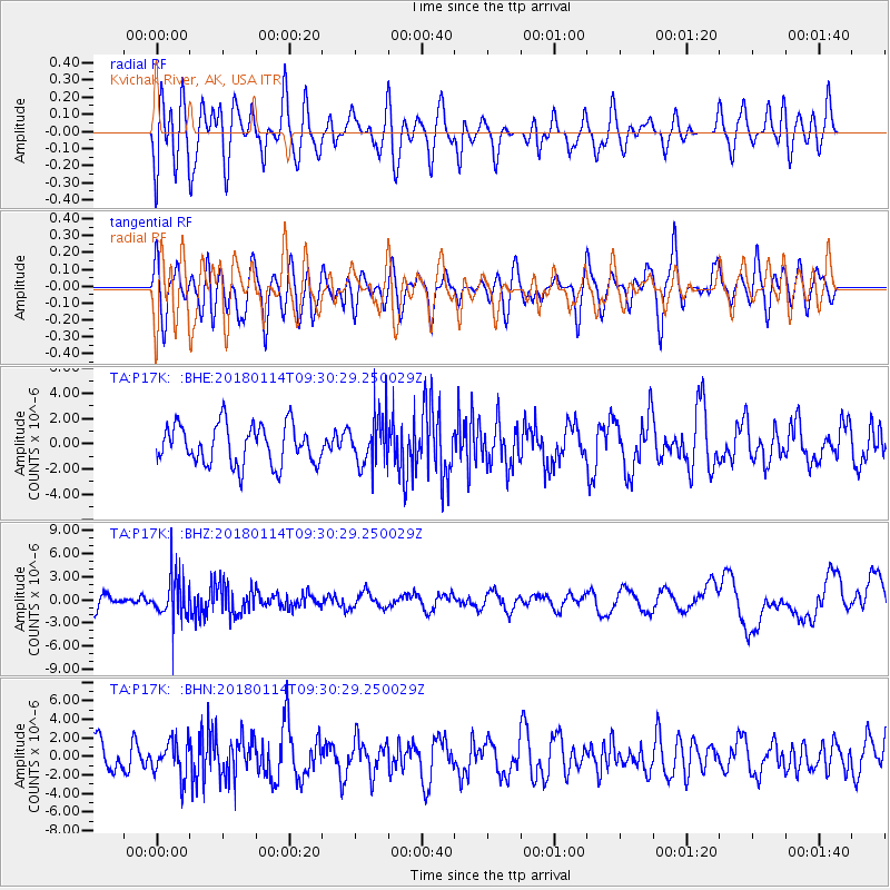
P17K Kvichak River, AK, USA - Earthquake Result Viewer
*The percent match for this event was below the threshold and hence no stack was calculated.
| Earthquake location: |
Hindu Kush Region, Afghanistan |
| Earthquake latitude/longitude: |
36.5/70.7 |
| Earthquake time(UTC): |
2018/01/14 (014) 09:19:29 GMT |
| Earthquake Depth: |
200 km |
| Earthquake Magnitude: |
5.3 Mww |
| Earthquake Catalog/Contributor: |
NEIC PDE/us |
|
| Network: |
TA USArray Transportable Network (new EarthScope stations) |
| Station: |
P17K Kvichak River, AK, USA |
| Lat/Lon: |
59.20 N/156.44 W |
| Elevation: |
91 m |
|
| Distance: |
77.0 deg |
| Az: |
22.792 deg |
| Baz: |
322.636 deg |
| Ray Param: |
$rayparam |
*The percent match for this event was below the threshold and hence was not used in the summary stack. |
|
| Radial Match: |
51.021523 % |
| Radial Bump: |
400 |
| Transverse Match: |
51.23925 % |
| Transverse Bump: |
400 |
| SOD ConfigId: |
13570011 |
| Insert Time: |
2019-04-29 13:51:40.834 +0000 |
| GWidth: |
2.5 |
| Max Bumps: |
400 |
| Tol: |
0.001 |
|
Signal To Noise
| Channel | StoN | STA | LTA |
| TA:P17K: :BHZ:20180114T09:30:29.250029Z | 4.020379 | 2.9694718E-6 | 7.386049E-7 |
| TA:P17K: :BHN:20180114T09:30:29.250029Z | 0.87718815 | 1.8843618E-6 | 2.1481844E-6 |
| TA:P17K: :BHE:20180114T09:30:29.250029Z | 1.2391812 | 1.9435486E-6 | 1.5684136E-6 |
| Arrivals |
| Ps | |
| PpPs | |
| PsPs/PpSs | |


