You are here: Home > Network List > TA - USArray Transportable Network (new EarthScope stations) Stations List
> Station F21K Alatna River, AK, USA > Earthquake Result Viewer
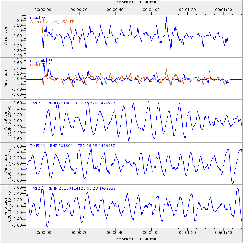
F21K Alatna River, AK, USA - Earthquake Result Viewer
*The percent match for this event was below the threshold and hence no stack was calculated.
| Earthquake location: |
Near N Coast Of New Guinea, P.N.G. |
| Earthquake latitude/longitude: |
-4.8/144.9 |
| Earthquake time(UTC): |
2018/01/14 (014) 21:54:36 GMT |
| Earthquake Depth: |
65 km |
| Earthquake Magnitude: |
5.5 Mww |
| Earthquake Catalog/Contributor: |
NEIC PDE/us |
|
| Network: |
TA USArray Transportable Network (new EarthScope stations) |
| Station: |
F21K Alatna River, AK, USA |
| Lat/Lon: |
67.22 N/153.48 W |
| Elevation: |
597 m |
|
| Distance: |
83.8 deg |
| Az: |
20.156 deg |
| Baz: |
241.873 deg |
| Ray Param: |
$rayparam |
*The percent match for this event was below the threshold and hence was not used in the summary stack. |
|
| Radial Match: |
60.48961 % |
| Radial Bump: |
400 |
| Transverse Match: |
76.55753 % |
| Transverse Bump: |
400 |
| SOD ConfigId: |
13570011 |
| Insert Time: |
2019-04-29 13:54:53.006 +0000 |
| GWidth: |
2.5 |
| Max Bumps: |
400 |
| Tol: |
0.001 |
|
Signal To Noise
| Channel | StoN | STA | LTA |
| TA:F21K: :BHZ:20180114T22:06:28.149993Z | 1.5989233 | 3.4290136E-7 | 2.1445767E-7 |
| TA:F21K: :BHN:20180114T22:06:28.149993Z | 1.7744226 | 4.3552703E-7 | 2.4544718E-7 |
| TA:F21K: :BHE:20180114T22:06:28.149993Z | 0.8336269 | 2.331968E-7 | 2.797376E-7 |
| Arrivals |
| Ps | |
| PpPs | |
| PsPs/PpSs | |


