You are here: Home > Network List > US - United States National Seismic Network Stations List
> Station AHID Auburn Hatchery, Idaho, USA > Earthquake Result Viewer
AHID Auburn Hatchery, Idaho, USA - Earthquake Result Viewer
| Earthquake location: |
Near Coast Of Ecuador |
| Earthquake latitude/longitude: |
0.4/-79.9 |
| Earthquake time(UTC): |
2016/04/16 (107) 23:58:37 GMT |
| Earthquake Depth: |
19 km |
| Earthquake Magnitude: |
7.8 MWW, 7.4 MI |
| Earthquake Catalog/Contributor: |
NEIC PDE/NEIC COMCAT |
|
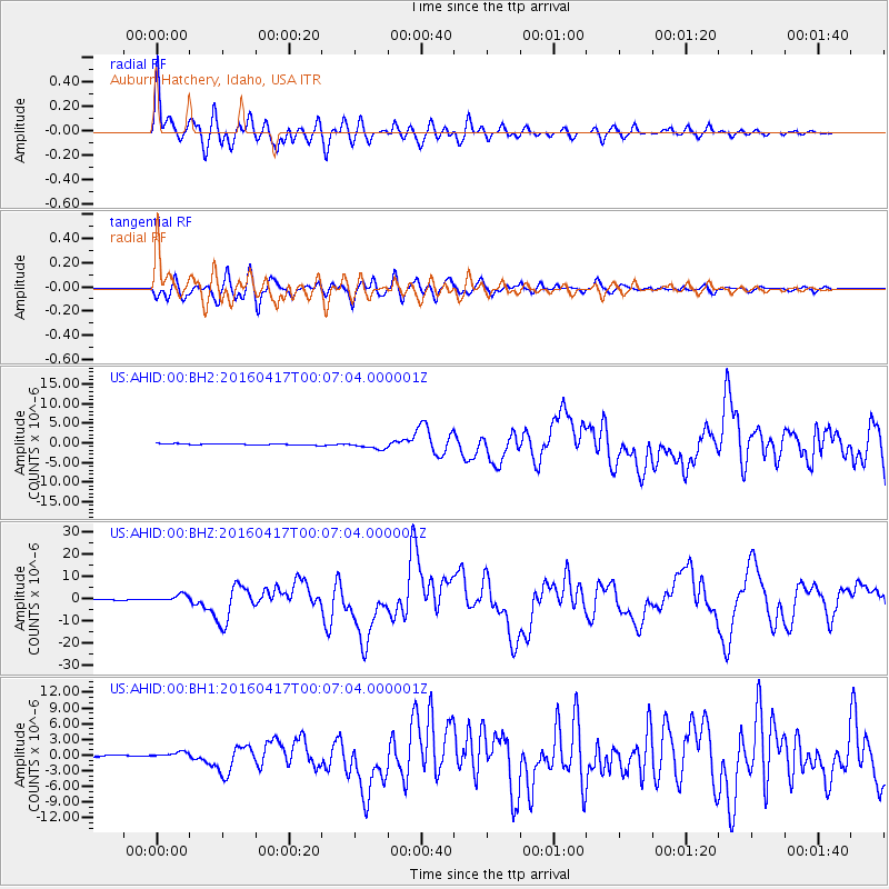
| Network: |
US United States National Seismic Network |
| Station: |
AHID Auburn Hatchery, Idaho, USA |
| Lat/Lon: |
42.77 N/111.10 W |
| Elevation: |
1960 m |
|
| Distance: |
50.6 deg |
| Az: |
330.462 deg |
| Baz: |
137.976 deg |
| Ray Param: |
0.067912444 |
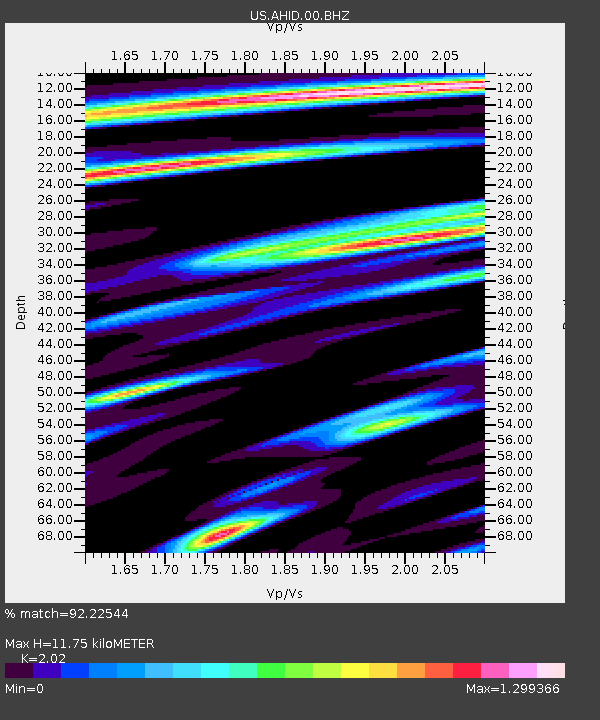
| Estimated Moho Depth: |
11.75 km |
| Estimated Crust Vp/Vs: |
2.02 |
| Assumed Crust Vp: |
6.207 km/s |
| Estimated Crust Vs: |
3.073 km/s |
| Estimated Crust Poisson's Ratio: |
0.34 |
|
| Radial Match: |
92.22544 % |
| Radial Bump: |
400 |
| Transverse Match: |
89.969124 % |
| Transverse Bump: |
400 |
| SOD ConfigId: |
1475611 |
| Insert Time: |
2016-05-01 00:14:54.532 +0000 |
| GWidth: |
2.5 |
| Max Bumps: |
400 |
| Tol: |
0.001 |
|
Signal To Noise
| Channel | StoN | STA | LTA |
| US:AHID:00:BHZ:20160417T00:07:04.000001Z | 9.733954 | 1.7142709E-6 | 1.7611248E-7 |
| US:AHID:00:BH1:20160417T00:07:04.000001Z | 3.0971258 | 6.310428E-7 | 2.0375109E-7 |
| US:AHID:00:BH2:20160417T00:07:04.000001Z | 5.8569894 | 9.017232E-7 | 1.5395676E-7 |
| Arrivals |
| Ps | 2.0 SECOND |
| PpPs | 5.5 SECOND |
| PsPs/PpSs | 7.5 SECOND |


