You are here: Home > Network List > TA - USArray Transportable Network (new EarthScope stations) Stations List
> Station G22K Bettles, AK, USA > Earthquake Result Viewer
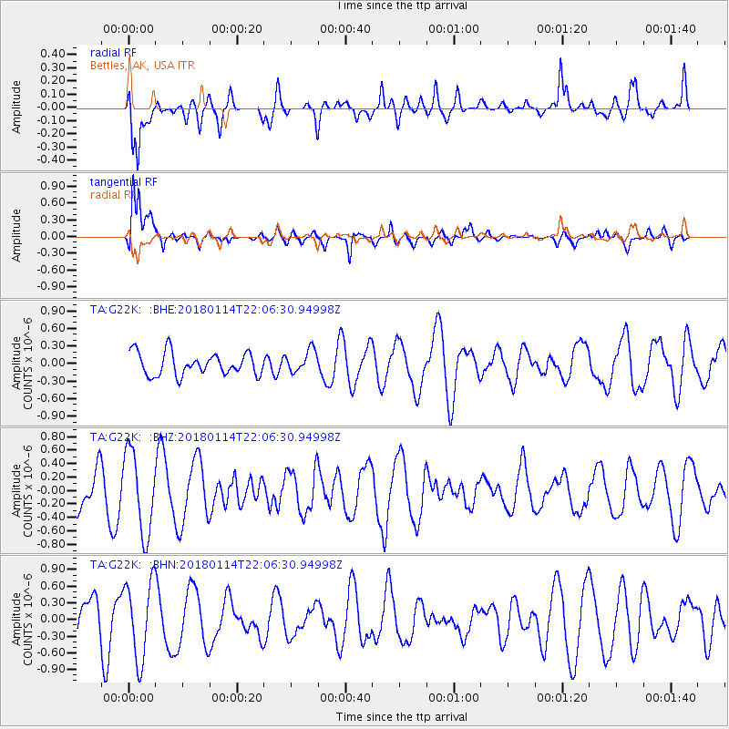
G22K Bettles, AK, USA - Earthquake Result Viewer
*The percent match for this event was below the threshold and hence no stack was calculated.
| Earthquake location: |
Near N Coast Of New Guinea, P.N.G. |
| Earthquake latitude/longitude: |
-4.8/144.9 |
| Earthquake time(UTC): |
2018/01/14 (014) 21:54:36 GMT |
| Earthquake Depth: |
65 km |
| Earthquake Magnitude: |
5.5 Mww |
| Earthquake Catalog/Contributor: |
NEIC PDE/us |
|
| Network: |
TA USArray Transportable Network (new EarthScope stations) |
| Station: |
G22K Bettles, AK, USA |
| Lat/Lon: |
66.92 N/151.51 W |
| Elevation: |
205 m |
|
| Distance: |
84.4 deg |
| Az: |
20.782 deg |
| Baz: |
243.755 deg |
| Ray Param: |
$rayparam |
*The percent match for this event was below the threshold and hence was not used in the summary stack. |
|
| Radial Match: |
48.109943 % |
| Radial Bump: |
400 |
| Transverse Match: |
73.22208 % |
| Transverse Bump: |
400 |
| SOD ConfigId: |
13570011 |
| Insert Time: |
2019-04-29 13:54:55.191 +0000 |
| GWidth: |
2.5 |
| Max Bumps: |
400 |
| Tol: |
0.001 |
|
Signal To Noise
| Channel | StoN | STA | LTA |
| TA:G22K: :BHZ:20180114T22:06:30.94998Z | 1.6169511 | 6.082233E-7 | 3.761544E-7 |
| TA:G22K: :BHN:20180114T22:06:30.94998Z | 1.4589775 | 7.045188E-7 | 4.8288535E-7 |
| TA:G22K: :BHE:20180114T22:06:30.94998Z | 0.99189585 | 1.9321523E-7 | 1.9479387E-7 |
| Arrivals |
| Ps | |
| PpPs | |
| PsPs/PpSs | |


