You are here: Home > Network List > TA - USArray Transportable Network (new EarthScope stations) Stations List
> Station R32K Eaglecrest, AK, USA > Earthquake Result Viewer
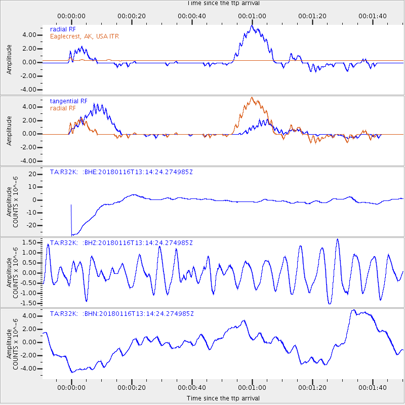
R32K Eaglecrest, AK, USA - Earthquake Result Viewer
*The percent match for this event was below the threshold and hence no stack was calculated.
| Earthquake location: |
Near N Coast Of New Guinea, P.N.G. |
| Earthquake latitude/longitude: |
-4.7/144.1 |
| Earthquake time(UTC): |
2018/01/16 (016) 13:02:07 GMT |
| Earthquake Depth: |
76 km |
| Earthquake Magnitude: |
5.3 Mww |
| Earthquake Catalog/Contributor: |
NEIC PDE/us |
|
| Network: |
TA USArray Transportable Network (new EarthScope stations) |
| Station: |
R32K Eaglecrest, AK, USA |
| Lat/Lon: |
58.27 N/134.52 W |
| Elevation: |
386 m |
|
| Distance: |
89.4 deg |
| Az: |
31.501 deg |
| Baz: |
260.276 deg |
| Ray Param: |
$rayparam |
*The percent match for this event was below the threshold and hence was not used in the summary stack. |
|
| Radial Match: |
18.06645 % |
| Radial Bump: |
400 |
| Transverse Match: |
24.130768 % |
| Transverse Bump: |
400 |
| SOD ConfigId: |
13570011 |
| Insert Time: |
2019-04-29 13:58:46.024 +0000 |
| GWidth: |
2.5 |
| Max Bumps: |
400 |
| Tol: |
0.001 |
|
Signal To Noise
| Channel | StoN | STA | LTA |
| TA:R32K: :BHZ:20180116T13:14:24.274985Z | 0.55250764 | 5.337038E-7 | 9.659665E-7 |
| TA:R32K: :BHN:20180116T13:14:24.274985Z | 2.670174 | 9.63788E-6 | 3.6094577E-6 |
| TA:R32K: :BHE:20180116T13:14:24.274985Z | 0.78199697 | 7.830065E-6 | 1.0012911E-5 |
| Arrivals |
| Ps | |
| PpPs | |
| PsPs/PpSs | |


