You are here: Home > Network List > TA - USArray Transportable Network (new EarthScope stations) Stations List
> Station Z23A Rita Site, White Sands Missle Range, NM, USA > Earthquake Result Viewer
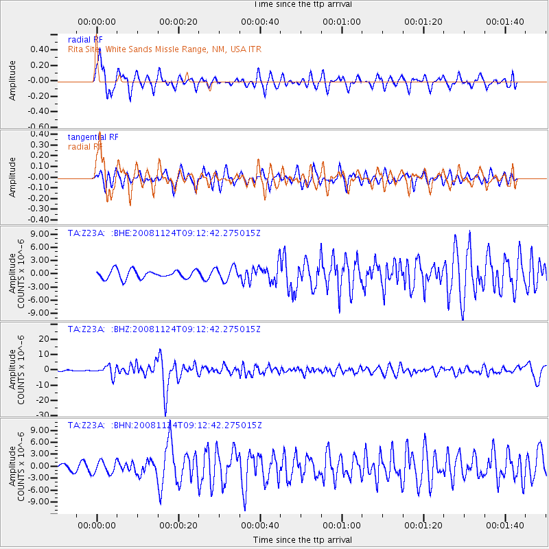
Z23A Rita Site, White Sands Missle Range, NM, USA - Earthquake Result Viewer
*The percent match for this event was below the threshold and hence no stack was calculated.
| Earthquake location: |
Sea Of Okhotsk |
| Earthquake latitude/longitude: |
54.2/154.3 |
| Earthquake time(UTC): |
2008/11/24 (329) 09:02:58 GMT |
| Earthquake Depth: |
492 km |
| Earthquake Magnitude: |
6.5 MB, 7.3 MW, 7.3 MW |
| Earthquake Catalog/Contributor: |
WHDF/NEIC |
|
| Network: |
TA USArray Transportable Network (new EarthScope stations) |
| Station: |
Z23A Rita Site, White Sands Missle Range, NM, USA |
| Lat/Lon: |
33.26 N/106.23 W |
| Elevation: |
1278 m |
|
| Distance: |
68.8 deg |
| Az: |
62.405 deg |
| Baz: |
321.579 deg |
| Ray Param: |
$rayparam |
*The percent match for this event was below the threshold and hence was not used in the summary stack. |
|
| Radial Match: |
71.3015 % |
| Radial Bump: |
400 |
| Transverse Match: |
59.70288 % |
| Transverse Bump: |
391 |
| SOD ConfigId: |
2658 |
| Insert Time: |
2010-03-06 07:59:51.421 +0000 |
| GWidth: |
2.5 |
| Max Bumps: |
400 |
| Tol: |
0.001 |
|
Signal To Noise
| Channel | StoN | STA | LTA |
| TA:Z23A: :BHZ:20081124T09:12:42.275015Z | 12.701814 | 3.2896073E-6 | 2.589872E-7 |
| TA:Z23A: :BHN:20081124T09:12:42.275015Z | 2.326599 | 1.5331317E-6 | 6.5895836E-7 |
| TA:Z23A: :BHE:20081124T09:12:42.275015Z | 1.5484211 | 1.4908792E-6 | 9.628384E-7 |
| Arrivals |
| Ps | |
| PpPs | |
| PsPs/PpSs | |


