You are here: Home > Network List > US - United States National Seismic Network Stations List
> Station GOGA Godfrey, Georgia, USA > Earthquake Result Viewer
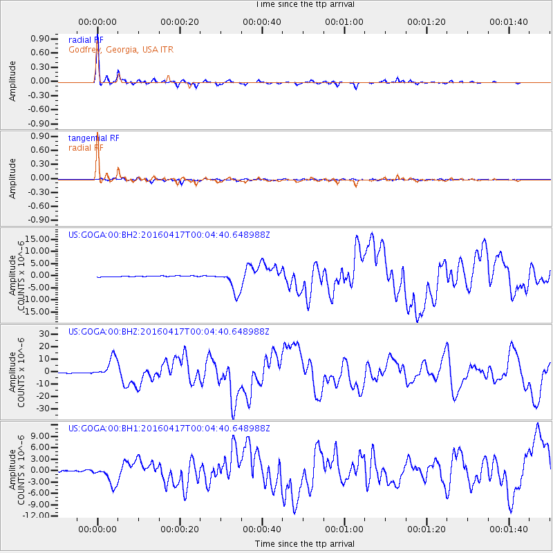
GOGA Godfrey, Georgia, USA - Earthquake Result Viewer
| Earthquake location: |
Near Coast Of Ecuador |
| Earthquake latitude/longitude: |
0.4/-79.9 |
| Earthquake time(UTC): |
2016/04/16 (107) 23:58:37 GMT |
| Earthquake Depth: |
19 km |
| Earthquake Magnitude: |
7.8 MWW, 7.4 MI |
| Earthquake Catalog/Contributor: |
NEIC PDE/NEIC COMCAT |
|
| Network: |
US United States National Seismic Network |
| Station: |
GOGA Godfrey, Georgia, USA |
| Lat/Lon: |
33.41 N/83.47 W |
| Elevation: |
150 m |
|
| Distance: |
33.0 deg |
| Az: |
354.584 deg |
| Baz: |
173.521 deg |
| Ray Param: |
0.078375414 |
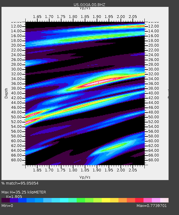
| Estimated Moho Depth: |
35.25 km |
| Estimated Crust Vp/Vs: |
1.90 |
| Assumed Crust Vp: |
6.565 km/s |
| Estimated Crust Vs: |
3.446 km/s |
| Estimated Crust Poisson's Ratio: |
0.31 |
|
| Radial Match: |
95.85854 % |
| Radial Bump: |
235 |
| Transverse Match: |
85.78515 % |
| Transverse Bump: |
400 |
| SOD ConfigId: |
1475611 |
| Insert Time: |
2016-05-01 00:16:56.612 +0000 |
| GWidth: |
2.5 |
| Max Bumps: |
400 |
| Tol: |
0.001 |
|
Signal To Noise
| Channel | StoN | STA | LTA |
| US:GOGA:00:BHZ:20160417T00:04:40.648988Z | 32.830196 | 8.461373E-6 | 2.5773141E-7 |
| US:GOGA:00:BH1:20160417T00:04:40.648988Z | 14.059673 | 2.5311226E-6 | 1.8002713E-7 |
| US:GOGA:00:BH2:20160417T00:04:40.648988Z | 28.291676 | 4.860692E-6 | 1.7180645E-7 |
| Arrivals |
| Ps | 5.2 SECOND |
| PpPs | 14 SECOND |
| PsPs/PpSs | 20 SECOND |


