You are here: Home > Network List > CI - Caltech Regional Seismic Network Stations List
> Station IRM Iron Mountain Pumping Station, Eagle Mtn., CA, USA > Earthquake Result Viewer
IRM Iron Mountain Pumping Station, Eagle Mtn., CA, USA - Earthquake Result Viewer
| Earthquake location: |
Kuril Islands |
| Earthquake latitude/longitude: |
46.6/153.3 |
| Earthquake time(UTC): |
2006/11/15 (319) 11:14:13 GMT |
| Earthquake Depth: |
10 km |
| Earthquake Magnitude: |
6.5 MB, 7.8 MS, 8.3 MW, 7.9 MW |
| Earthquake Catalog/Contributor: |
WHDF/NEIC |
|
| Network: |
CI Caltech Regional Seismic Network |
| Station: |
IRM Iron Mountain Pumping Station, Eagle Mtn., CA, USA |
| Lat/Lon: |
34.16 N/115.15 W |
| Elevation: |
567 m |
|
| Distance: |
67.1 deg |
| Az: |
64.124 deg |
| Baz: |
311.561 deg |
| Ray Param: |
0.05716654 |
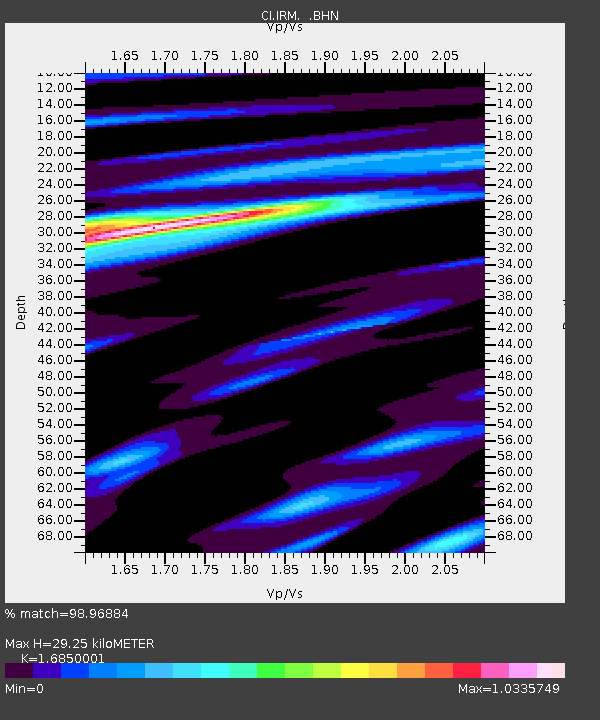
| Estimated Moho Depth: |
29.25 km |
| Estimated Crust Vp/Vs: |
1.69 |
| Assumed Crust Vp: |
6.276 km/s |
| Estimated Crust Vs: |
3.725 km/s |
| Estimated Crust Poisson's Ratio: |
0.23 |
|
| Radial Match: |
98.96884 % |
| Radial Bump: |
268 |
| Transverse Match: |
97.91273 % |
| Transverse Bump: |
318 |
| SOD ConfigId: |
2564 |
| Insert Time: |
2010-02-26 01:44:04.171 +0000 |
| GWidth: |
2.5 |
| Max Bumps: |
400 |
| Tol: |
0.001 |
|

Signal To Noise
| Channel | StoN | STA | LTA |
| CI:IRM: :BHN:20061115T11:24:36.046013Z | 1.0516214 | 3.254585E-7 | 3.0948257E-7 |
| CI:IRM: :BHE:20061115T11:24:36.046013Z | 5.017247 | 8.072181E-7 | 1.6088865E-7 |
| CI:IRM: :BHZ:20061115T11:24:36.046013Z | 4.7812204 | 1.4263206E-6 | 2.983173E-7 |
| Arrivals |
| Ps | 3.3 SECOND |
| PpPs | 12 SECOND |
| PsPs/PpSs | 15 SECOND |


