You are here: Home > Network List > TA - USArray Transportable Network (new EarthScope stations) Stations List
> Station Z23A Rita Site, White Sands Missle Range, NM, USA > Earthquake Result Viewer
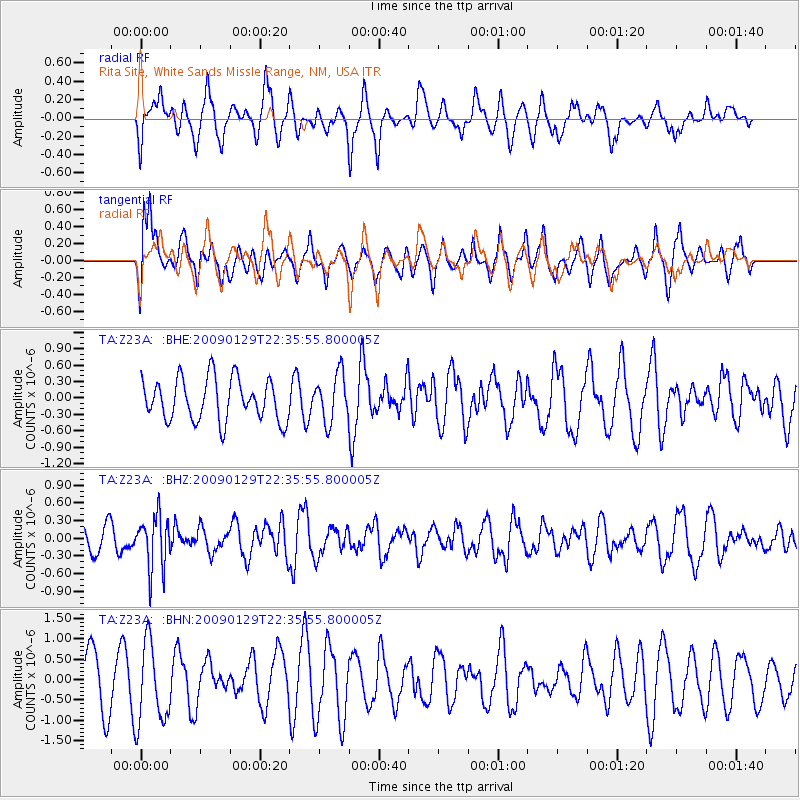
Z23A Rita Site, White Sands Missle Range, NM, USA - Earthquake Result Viewer
*The percent match for this event was below the threshold and hence no stack was calculated.
| Earthquake location: |
Western Brazil |
| Earthquake latitude/longitude: |
-8.1/-71.4 |
| Earthquake time(UTC): |
2009/01/29 (029) 22:28:05 GMT |
| Earthquake Depth: |
602 km |
| Earthquake Magnitude: |
5.7 MW, 5.3 MB, 5.6 MW |
| Earthquake Catalog/Contributor: |
WHDF/NEIC |
|
| Network: |
TA USArray Transportable Network (new EarthScope stations) |
| Station: |
Z23A Rita Site, White Sands Missle Range, NM, USA |
| Lat/Lon: |
33.26 N/106.23 W |
| Elevation: |
1278 m |
|
| Distance: |
52.8 deg |
| Az: |
323.08 deg |
| Baz: |
134.774 deg |
| Ray Param: |
$rayparam |
*The percent match for this event was below the threshold and hence was not used in the summary stack. |
|
| Radial Match: |
57.049526 % |
| Radial Bump: |
400 |
| Transverse Match: |
54.244408 % |
| Transverse Bump: |
400 |
| SOD ConfigId: |
2658 |
| Insert Time: |
2010-03-06 08:00:35.713 +0000 |
| GWidth: |
2.5 |
| Max Bumps: |
400 |
| Tol: |
0.001 |
|
Signal To Noise
| Channel | StoN | STA | LTA |
| TA:Z23A: :BHZ:20090129T22:35:55.800005Z | 2.6660662 | 4.511522E-7 | 1.6922019E-7 |
| TA:Z23A: :BHN:20090129T22:35:55.800005Z | 1.3666391 | 9.93493E-7 | 7.2696076E-7 |
| TA:Z23A: :BHE:20090129T22:35:55.800005Z | 1.1382068 | 4.3644326E-7 | 3.834481E-7 |
| Arrivals |
| Ps | |
| PpPs | |
| PsPs/PpSs | |


