You are here: Home > Network List > US - United States National Seismic Network Stations List
> Station MNTX Cornudas Mountains, Texas, USA > Earthquake Result Viewer
MNTX Cornudas Mountains, Texas, USA - Earthquake Result Viewer
| Earthquake location: |
Near Coast Of Ecuador |
| Earthquake latitude/longitude: |
0.4/-79.9 |
| Earthquake time(UTC): |
2016/04/16 (107) 23:58:37 GMT |
| Earthquake Depth: |
19 km |
| Earthquake Magnitude: |
7.8 MWW, 7.4 MI |
| Earthquake Catalog/Contributor: |
NEIC PDE/NEIC COMCAT |
|
| Network: |
US United States National Seismic Network |
| Station: |
MNTX Cornudas Mountains, Texas, USA |
| Lat/Lon: |
31.70 N/105.38 W |
| Elevation: |
404 m |
|
| Distance: |
39.4 deg |
| Az: |
324.738 deg |
| Baz: |
137.37 deg |
| Ray Param: |
0.07500114 |
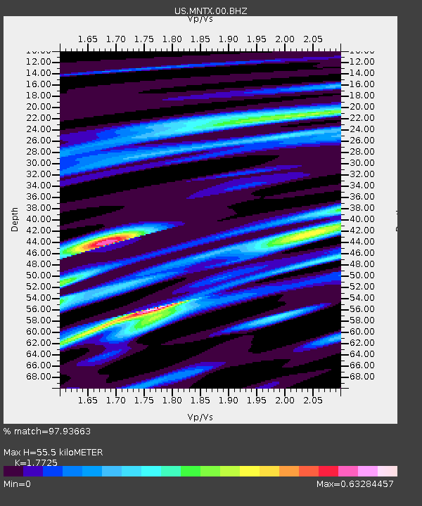
| Estimated Moho Depth: |
55.5 km |
| Estimated Crust Vp/Vs: |
1.77 |
| Assumed Crust Vp: |
6.361 km/s |
| Estimated Crust Vs: |
3.588 km/s |
| Estimated Crust Poisson's Ratio: |
0.27 |
|
| Radial Match: |
97.93663 % |
| Radial Bump: |
222 |
| Transverse Match: |
93.460686 % |
| Transverse Bump: |
400 |
| SOD ConfigId: |
1475611 |
| Insert Time: |
2016-05-01 00:20:04.241 +0000 |
| GWidth: |
2.5 |
| Max Bumps: |
400 |
| Tol: |
0.001 |
|
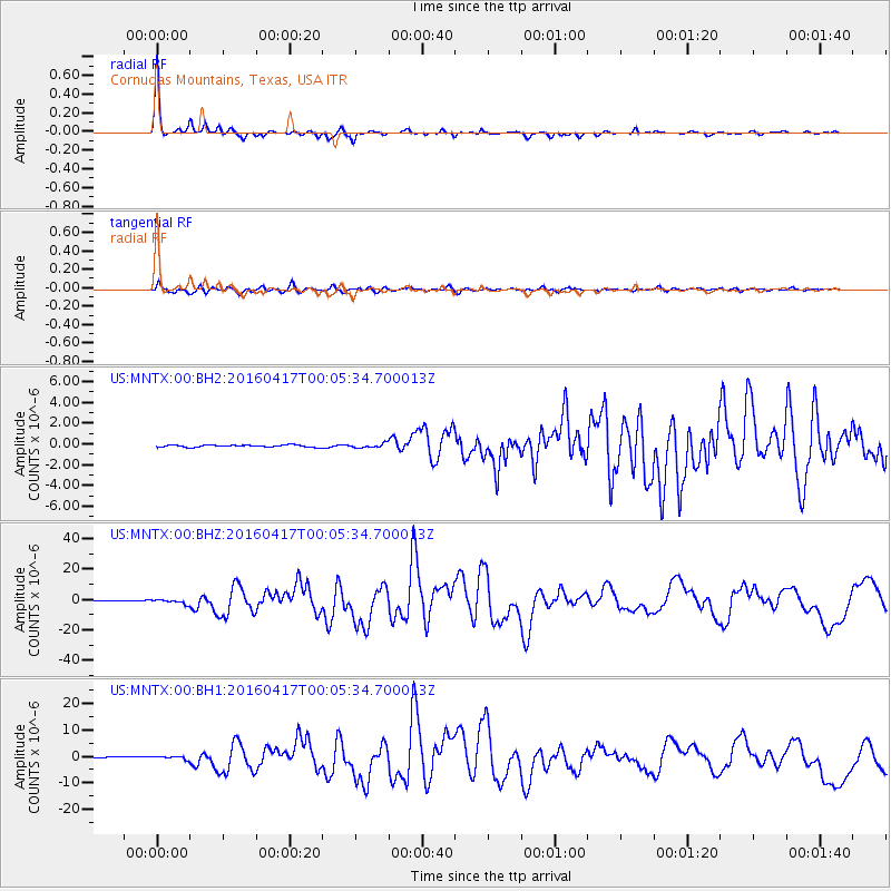
Signal To Noise
| Channel | StoN | STA | LTA |
| US:MNTX:00:BHZ:20160417T00:05:34.700013Z | 5.434293 | 1.3770091E-6 | 2.5339253E-7 |
| US:MNTX:00:BH1:20160417T00:05:34.700013Z | 3.4771025 | 5.8642263E-7 | 1.6865266E-7 |
| US:MNTX:00:BH2:20160417T00:05:34.700013Z | 2.0043178 | 2.0711376E-7 | 1.033338E-7 |
| Arrivals |
| Ps | 7.2 SECOND |
| PpPs | 23 SECOND |
| PsPs/PpSs | 30 SECOND |


