You are here: Home > Network List > TA - USArray Transportable Network (new EarthScope stations) Stations List
> Station B18K Kokolik River, AK, USA > Earthquake Result Viewer
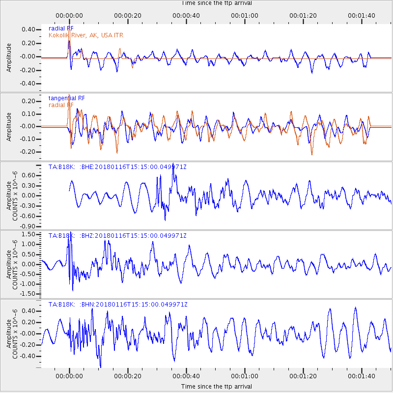
B18K Kokolik River, AK, USA - Earthquake Result Viewer
*The percent match for this event was below the threshold and hence no stack was calculated.
| Earthquake location: |
Off Coast Of Costa Rica |
| Earthquake latitude/longitude: |
10.9/-86.3 |
| Earthquake time(UTC): |
2018/01/16 (016) 15:03:54 GMT |
| Earthquake Depth: |
31 km |
| Earthquake Magnitude: |
5.9 Mww |
| Earthquake Catalog/Contributor: |
NEIC PDE/us |
|
| Network: |
TA USArray Transportable Network (new EarthScope stations) |
| Station: |
B18K Kokolik River, AK, USA |
| Lat/Lon: |
69.36 N/161.80 W |
| Elevation: |
222 m |
|
| Distance: |
74.7 deg |
| Az: |
339.161 deg |
| Baz: |
99.776 deg |
| Ray Param: |
$rayparam |
*The percent match for this event was below the threshold and hence was not used in the summary stack. |
|
| Radial Match: |
55.362843 % |
| Radial Bump: |
400 |
| Transverse Match: |
46.817726 % |
| Transverse Bump: |
400 |
| SOD ConfigId: |
13570011 |
| Insert Time: |
2019-04-29 14:06:33.396 +0000 |
| GWidth: |
2.5 |
| Max Bumps: |
400 |
| Tol: |
0.001 |
|
Signal To Noise
| Channel | StoN | STA | LTA |
| TA:B18K: :BHZ:20180116T15:15:00.049971Z | 4.53503 | 7.371791E-7 | 1.6255221E-7 |
| TA:B18K: :BHN:20180116T15:15:00.049971Z | 0.92441815 | 1.5448462E-7 | 1.6711553E-7 |
| TA:B18K: :BHE:20180116T15:15:00.049971Z | 1.5356698 | 3.3522937E-7 | 2.1829521E-7 |
| Arrivals |
| Ps | |
| PpPs | |
| PsPs/PpSs | |


