You are here: Home > Network List > TA - USArray Transportable Network (new EarthScope stations) Stations List
> Station U24A Moreno Valley High School, Angel Fire, NM, USA > Earthquake Result Viewer
U24A Moreno Valley High School, Angel Fire, NM, USA - Earthquake Result Viewer
| Earthquake location: |
Kuril Islands |
| Earthquake latitude/longitude: |
51.0/157.6 |
| Earthquake time(UTC): |
2008/07/24 (206) 01:43:16 GMT |
| Earthquake Depth: |
27 km |
| Earthquake Magnitude: |
6.0 MB, 6.0 MS, 6.2 MW, 6.2 MW |
| Earthquake Catalog/Contributor: |
WHDF/NEIC |
|
| Network: |
TA USArray Transportable Network (new EarthScope stations) |
| Station: |
U24A Moreno Valley High School, Angel Fire, NM, USA |
| Lat/Lon: |
36.41 N/105.28 W |
| Elevation: |
2573 m |
|
| Distance: |
66.8 deg |
| Az: |
60.583 deg |
| Baz: |
316.939 deg |
| Ray Param: |
0.057358555 |
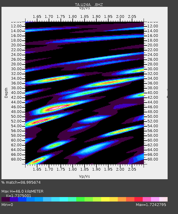
| Estimated Moho Depth: |
46.0 km |
| Estimated Crust Vp/Vs: |
1.74 |
| Assumed Crust Vp: |
6.316 km/s |
| Estimated Crust Vs: |
3.635 km/s |
| Estimated Crust Poisson's Ratio: |
0.25 |
|
| Radial Match: |
86.995674 % |
| Radial Bump: |
400 |
| Transverse Match: |
76.09673 % |
| Transverse Bump: |
400 |
| SOD ConfigId: |
2504 |
| Insert Time: |
2010-03-06 08:01:18.268 +0000 |
| GWidth: |
2.5 |
| Max Bumps: |
400 |
| Tol: |
0.001 |
|

Signal To Noise
| Channel | StoN | STA | LTA |
| TA:U24A: :BHZ:20080724T01:53:34.02501Z | 12.09855 | 1.398311E-6 | 1.15576746E-7 |
| TA:U24A: :BHN:20080724T01:53:34.02501Z | 4.4878364 | 5.1429254E-7 | 1.1459698E-7 |
| TA:U24A: :BHE:20080724T01:53:34.02501Z | 4.7779093 | 9.2128073E-7 | 1.9282089E-7 |
| Arrivals |
| Ps | 5.6 SECOND |
| PpPs | 19 SECOND |
| PsPs/PpSs | 25 SECOND |


