You are here: Home > Network List > TA - USArray Transportable Network (new EarthScope stations) Stations List
> Station L44A Lake County Forest Preserve, Grayslake, IL, USA > Earthquake Result Viewer
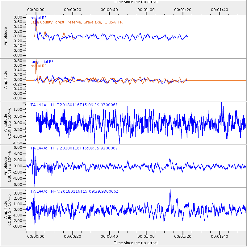
L44A Lake County Forest Preserve, Grayslake, IL, USA - Earthquake Result Viewer
*The percent match for this event was below the threshold and hence no stack was calculated.
| Earthquake location: |
Off Coast Of Costa Rica |
| Earthquake latitude/longitude: |
10.9/-86.3 |
| Earthquake time(UTC): |
2018/01/16 (016) 15:03:54 GMT |
| Earthquake Depth: |
31 km |
| Earthquake Magnitude: |
5.9 Mww |
| Earthquake Catalog/Contributor: |
NEIC PDE/us |
|
| Network: |
TA USArray Transportable Network (new EarthScope stations) |
| Station: |
L44A Lake County Forest Preserve, Grayslake, IL, USA |
| Lat/Lon: |
42.18 N/87.91 W |
| Elevation: |
202 m |
|
| Distance: |
31.2 deg |
| Az: |
357.751 deg |
| Baz: |
177.027 deg |
| Ray Param: |
$rayparam |
*The percent match for this event was below the threshold and hence was not used in the summary stack. |
|
| Radial Match: |
72.93875 % |
| Radial Bump: |
382 |
| Transverse Match: |
60.70202 % |
| Transverse Bump: |
400 |
| SOD ConfigId: |
13570011 |
| Insert Time: |
2019-04-29 14:07:44.917 +0000 |
| GWidth: |
2.5 |
| Max Bumps: |
400 |
| Tol: |
0.001 |
|
Signal To Noise
| Channel | StoN | STA | LTA |
| TA:L44A: :HHZ:20180116T15:09:39.930006Z | 6.2377033 | 1.9200122E-6 | 3.0780757E-7 |
| TA:L44A: :HHN:20180116T15:09:39.930006Z | 2.5019863 | 1.0283347E-6 | 4.1100736E-7 |
| TA:L44A: :HHE:20180116T15:09:39.930006Z | 1.2611248 | 5.037354E-7 | 3.9943342E-7 |
| Arrivals |
| Ps | |
| PpPs | |
| PsPs/PpSs | |


