You are here: Home > Network List > TA - USArray Transportable Network (new EarthScope stations) Stations List
> Station R33M Jennings River, BC, CAN > Earthquake Result Viewer
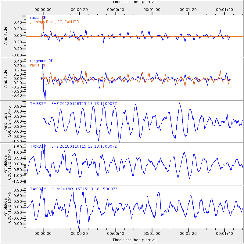
R33M Jennings River, BC, CAN - Earthquake Result Viewer
*The percent match for this event was below the threshold and hence no stack was calculated.
| Earthquake location: |
Off Coast Of Costa Rica |
| Earthquake latitude/longitude: |
10.9/-86.3 |
| Earthquake time(UTC): |
2018/01/16 (016) 15:03:54 GMT |
| Earthquake Depth: |
31 km |
| Earthquake Magnitude: |
5.9 Mww |
| Earthquake Catalog/Contributor: |
NEIC PDE/us |
|
| Network: |
TA USArray Transportable Network (new EarthScope stations) |
| Station: |
R33M Jennings River, BC, CAN |
| Lat/Lon: |
59.39 N/130.97 W |
| Elevation: |
1437 m |
|
| Distance: |
58.7 deg |
| Az: |
335.125 deg |
| Baz: |
126.16 deg |
| Ray Param: |
$rayparam |
*The percent match for this event was below the threshold and hence was not used in the summary stack. |
|
| Radial Match: |
51.78453 % |
| Radial Bump: |
400 |
| Transverse Match: |
75.65856 % |
| Transverse Bump: |
400 |
| SOD ConfigId: |
13570011 |
| Insert Time: |
2019-04-29 14:08:12.183 +0000 |
| GWidth: |
2.5 |
| Max Bumps: |
400 |
| Tol: |
0.001 |
|
Signal To Noise
| Channel | StoN | STA | LTA |
| TA:R33M: :BHZ:20180116T15:13:18.150007Z | 1.9331105 | 9.117725E-7 | 4.7166083E-7 |
| TA:R33M: :BHN:20180116T15:13:18.150007Z | 2.5193007 | 5.2827335E-7 | 2.0969047E-7 |
| TA:R33M: :BHE:20180116T15:13:18.150007Z | 1.6067652 | 6.762262E-7 | 4.2086188E-7 |
| Arrivals |
| Ps | |
| PpPs | |
| PsPs/PpSs | |


