You are here: Home > Network List > TA - USArray Transportable Network (new EarthScope stations) Stations List
> Station U24A Moreno Valley High School, Angel Fire, NM, USA > Earthquake Result Viewer
U24A Moreno Valley High School, Angel Fire, NM, USA - Earthquake Result Viewer
| Earthquake location: |
Norwegian Sea |
| Earthquake latitude/longitude: |
72.2/0.9 |
| Earthquake time(UTC): |
2009/08/20 (232) 06:35:04 GMT |
| Earthquake Depth: |
6.0 km |
| Earthquake Magnitude: |
5.9 MB, 5.7 MS, 6.0 MW, 6.0 MW |
| Earthquake Catalog/Contributor: |
WHDF/NEIC |
|
| Network: |
TA USArray Transportable Network (new EarthScope stations) |
| Station: |
U24A Moreno Valley High School, Angel Fire, NM, USA |
| Lat/Lon: |
36.41 N/105.28 W |
| Elevation: |
2573 m |
|
| Distance: |
60.5 deg |
| Az: |
297.09 deg |
| Baz: |
19.842 deg |
| Ray Param: |
0.061526045 |
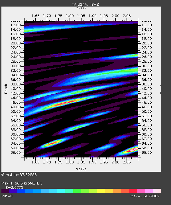
| Estimated Moho Depth: |
66.5 km |
| Estimated Crust Vp/Vs: |
2.08 |
| Assumed Crust Vp: |
6.316 km/s |
| Estimated Crust Vs: |
3.04 km/s |
| Estimated Crust Poisson's Ratio: |
0.35 |
|
| Radial Match: |
87.62886 % |
| Radial Bump: |
400 |
| Transverse Match: |
78.815414 % |
| Transverse Bump: |
400 |
| SOD ConfigId: |
2622 |
| Insert Time: |
2010-03-06 08:01:51.608 +0000 |
| GWidth: |
2.5 |
| Max Bumps: |
400 |
| Tol: |
0.001 |
|
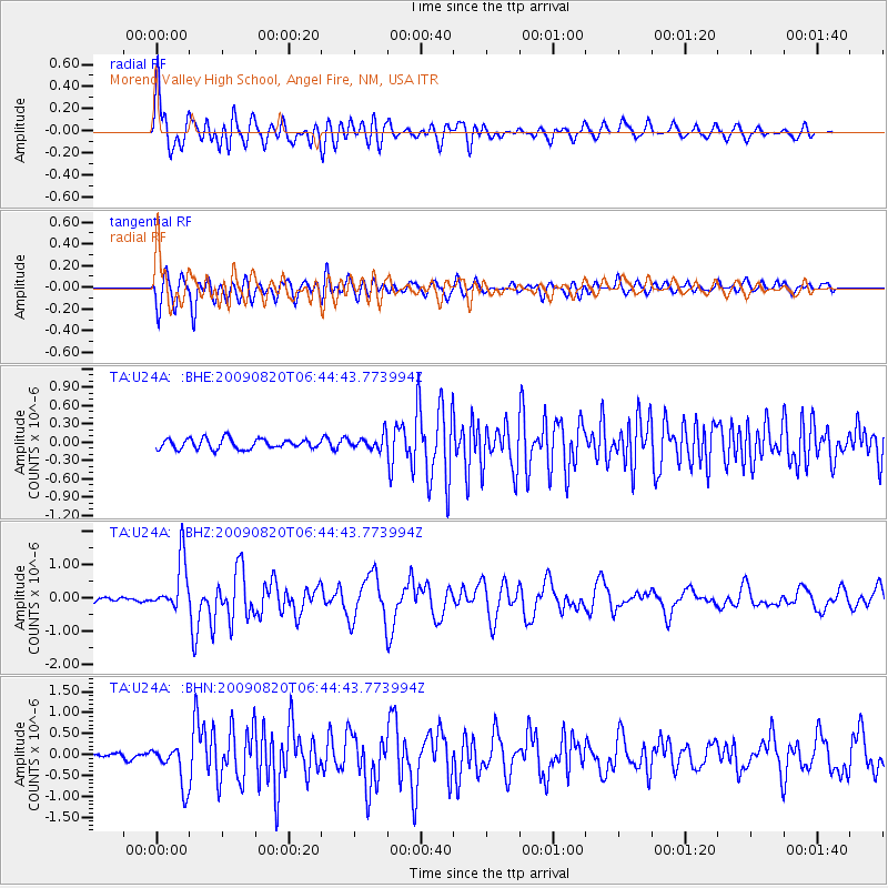
Signal To Noise
| Channel | StoN | STA | LTA |
| TA:U24A: :BHZ:20090820T06:44:43.773994Z | 10.249556 | 7.6358555E-7 | 7.4499376E-8 |
| TA:U24A: :BHN:20090820T06:44:43.773994Z | 7.042412 | 4.9788196E-7 | 7.069765E-8 |
| TA:U24A: :BHE:20090820T06:44:43.773994Z | 1.4143922 | 1.161101E-7 | 8.2091866E-8 |
| Arrivals |
| Ps | 12 SECOND |
| PpPs | 31 SECOND |
| PsPs/PpSs | 43 SECOND |


