You are here: Home > Network List > TA - USArray Transportable Network (new EarthScope stations) Stations List
> Station U24A Moreno Valley High School, Angel Fire, NM, USA > Earthquake Result Viewer
U24A Moreno Valley High School, Angel Fire, NM, USA - Earthquake Result Viewer
| Earthquake location: |
Santa Cruz Islands |
| Earthquake latitude/longitude: |
-12.4/166.1 |
| Earthquake time(UTC): |
2009/10/07 (280) 22:50:15 GMT |
| Earthquake Depth: |
21 km |
| Earthquake Magnitude: |
5.8 MB |
| Earthquake Catalog/Contributor: |
WHDF/NEIC |
|
| Network: |
TA USArray Transportable Network (new EarthScope stations) |
| Station: |
U24A Moreno Valley High School, Angel Fire, NM, USA |
| Lat/Lon: |
36.41 N/105.28 W |
| Elevation: |
2573 m |
|
| Distance: |
96.2 deg |
| Az: |
54.208 deg |
| Baz: |
259.233 deg |
| Ray Param: |
0.040585373 |
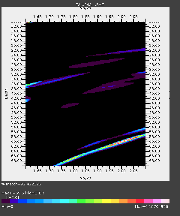
| Estimated Moho Depth: |
59.5 km |
| Estimated Crust Vp/Vs: |
2.01 |
| Assumed Crust Vp: |
6.316 km/s |
| Estimated Crust Vs: |
3.142 km/s |
| Estimated Crust Poisson's Ratio: |
0.34 |
|
| Radial Match: |
92.422226 % |
| Radial Bump: |
303 |
| Transverse Match: |
51.914417 % |
| Transverse Bump: |
264 |
| SOD ConfigId: |
2622 |
| Insert Time: |
2010-03-06 08:02:03.250 +0000 |
| GWidth: |
2.5 |
| Max Bumps: |
400 |
| Tol: |
0.001 |
|
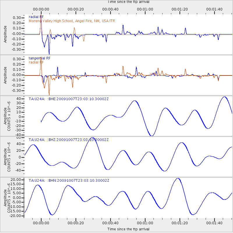
Signal To Noise
| Channel | StoN | STA | LTA |
| TA:U24A: :BHZ:20091007T23:03:10.30002Z | 0.94635516 | 1.33023E-5 | 1.4056351E-5 |
| TA:U24A: :BHN:20091007T23:03:10.30002Z | 0.74951994 | 9.940111E-6 | 1.326197E-5 |
| TA:U24A: :BHE:20091007T23:03:10.30002Z | 2.8432875 | 2.7458233E-5 | 9.657213E-6 |
| Arrivals |
| Ps | 9.7 SECOND |
| PpPs | 28 SECOND |
| PsPs/PpSs | 38 SECOND |


