You are here: Home > Network List > US - United States National Seismic Network Stations List
> Station WRAK Wrangell Island, Southeastern Alaska, Alaska, USA > Earthquake Result Viewer
WRAK Wrangell Island, Southeastern Alaska, Alaska, USA - Earthquake Result Viewer
| Earthquake location: |
Near Coast Of Ecuador |
| Earthquake latitude/longitude: |
0.4/-79.9 |
| Earthquake time(UTC): |
2016/04/16 (107) 23:58:37 GMT |
| Earthquake Depth: |
19 km |
| Earthquake Magnitude: |
7.8 MWW, 7.4 MI |
| Earthquake Catalog/Contributor: |
NEIC PDE/NEIC COMCAT |
|
| Network: |
US United States National Seismic Network |
| Station: |
WRAK Wrangell Island, Southeastern Alaska, Alaska, USA |
| Lat/Lon: |
56.42 N/132.35 W |
| Elevation: |
81 m |
|
| Distance: |
69.9 deg |
| Az: |
332.031 deg |
| Baz: |
122.439 deg |
| Ray Param: |
0.055348936 |
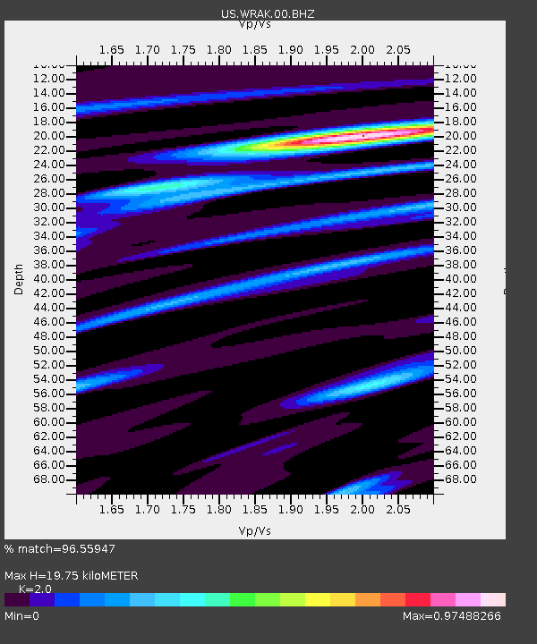
| Estimated Moho Depth: |
19.75 km |
| Estimated Crust Vp/Vs: |
2.00 |
| Assumed Crust Vp: |
6.597 km/s |
| Estimated Crust Vs: |
3.299 km/s |
| Estimated Crust Poisson's Ratio: |
0.33 |
|
| Radial Match: |
96.55947 % |
| Radial Bump: |
400 |
| Transverse Match: |
82.080086 % |
| Transverse Bump: |
400 |
| SOD ConfigId: |
1475611 |
| Insert Time: |
2016-05-01 00:22:10.472 +0000 |
| GWidth: |
2.5 |
| Max Bumps: |
400 |
| Tol: |
0.001 |
|
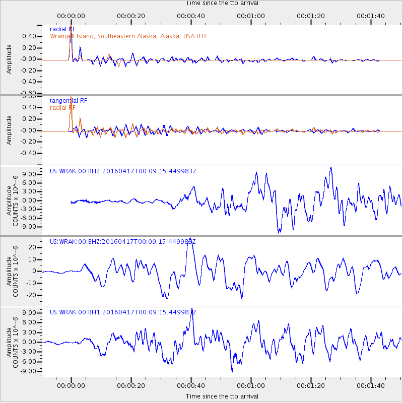
Signal To Noise
| Channel | StoN | STA | LTA |
| US:WRAK:00:BHZ:20160417T00:09:15.449983Z | 7.1155667 | 2.5900995E-6 | 3.6400468E-7 |
| US:WRAK:00:BH1:20160417T00:09:15.449983Z | 3.336508 | 5.509033E-7 | 1.6511373E-7 |
| US:WRAK:00:BH2:20160417T00:09:15.449983Z | 3.2273564 | 1.1616196E-6 | 3.5992915E-7 |
| Arrivals |
| Ps | 3.1 SECOND |
| PpPs | 8.7 SECOND |
| PsPs/PpSs | 12 SECOND |


