You are here: Home > Network List > UU - University of Utah Regional Network Stations List
> Station BRPU Butcher Ranch, Price, UT, USA old TA-P17A > Earthquake Result Viewer
BRPU Butcher Ranch, Price, UT, USA old TA-P17A - Earthquake Result Viewer
| Earthquake location: |
Near Coast Of Ecuador |
| Earthquake latitude/longitude: |
0.4/-79.9 |
| Earthquake time(UTC): |
2016/04/16 (107) 23:58:37 GMT |
| Earthquake Depth: |
19 km |
| Earthquake Magnitude: |
7.8 MWW, 7.4 MI |
| Earthquake Catalog/Contributor: |
NEIC PDE/NEIC COMCAT |
|
| Network: |
UU University of Utah Regional Network |
| Station: |
BRPU Butcher Ranch, Price, UT, USA old TA-P17A |
| Lat/Lon: |
39.47 N/110.74 W |
| Elevation: |
1687 m |
|
| Distance: |
48.0 deg |
| Az: |
327.78 deg |
| Baz: |
136.463 deg |
| Ray Param: |
0.069602706 |
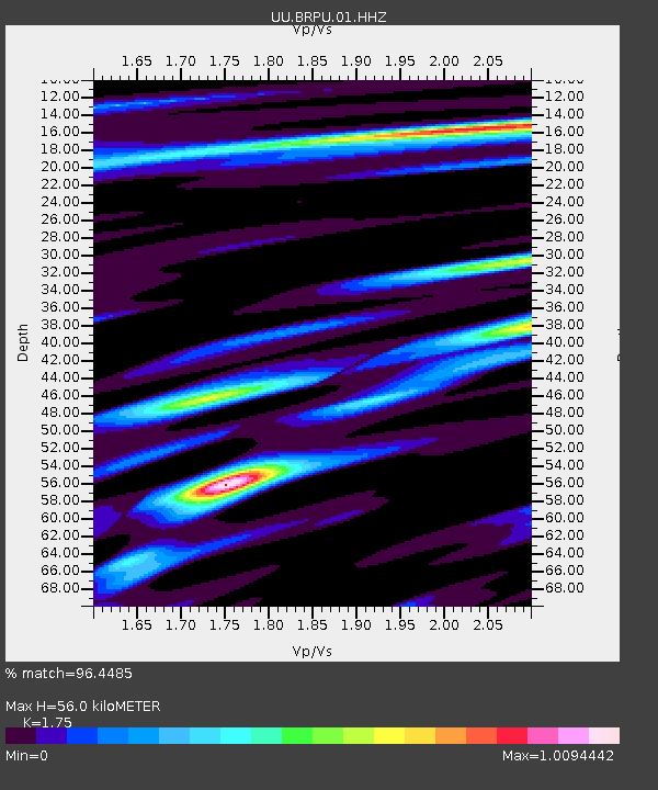
| Estimated Moho Depth: |
56.0 km |
| Estimated Crust Vp/Vs: |
1.75 |
| Assumed Crust Vp: |
6.207 km/s |
| Estimated Crust Vs: |
3.547 km/s |
| Estimated Crust Poisson's Ratio: |
0.26 |
|
| Radial Match: |
96.4485 % |
| Radial Bump: |
301 |
| Transverse Match: |
88.03365 % |
| Transverse Bump: |
400 |
| SOD ConfigId: |
1475611 |
| Insert Time: |
2016-05-01 00:22:40.248 +0000 |
| GWidth: |
2.5 |
| Max Bumps: |
400 |
| Tol: |
0.001 |
|

Signal To Noise
| Channel | StoN | STA | LTA |
| UU:BRPU:01:HHZ:20160417T00:06:44.138002Z | 8.798636 | 4.2100282E-8 | 4.784864E-9 |
| UU:BRPU:01:HHN:20160417T00:06:44.138002Z | 3.547602 | 2.0048876E-8 | 5.6513882E-9 |
| UU:BRPU:01:HHE:20160417T00:06:44.138002Z | 7.686188 | 1.4067321E-8 | 1.8302077E-9 |
| Arrivals |
| Ps | 7.2 SECOND |
| PpPs | 23 SECOND |
| PsPs/PpSs | 31 SECOND |


