You are here: Home > Network List > TA - USArray Transportable Network (new EarthScope stations) Stations List
> Station U24A Moreno Valley High School, Angel Fire, NM, USA > Earthquake Result Viewer
U24A Moreno Valley High School, Angel Fire, NM, USA - Earthquake Result Viewer
| Earthquake location: |
Baffin Bay |
| Earthquake latitude/longitude: |
75.4/-72.5 |
| Earthquake time(UTC): |
2009/07/07 (188) 19:11:46 GMT |
| Earthquake Depth: |
19 km |
| Earthquake Magnitude: |
5.9 MB, 5.7 MS, 6.1 MW, 6.0 MW |
| Earthquake Catalog/Contributor: |
WHDF/NEIC |
|
| Network: |
TA USArray Transportable Network (new EarthScope stations) |
| Station: |
U24A Moreno Valley High School, Angel Fire, NM, USA |
| Lat/Lon: |
36.41 N/105.28 W |
| Elevation: |
2573 m |
|
| Distance: |
41.9 deg |
| Az: |
220.881 deg |
| Baz: |
11.916 deg |
| Ray Param: |
0.0734582 |
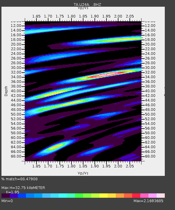
| Estimated Moho Depth: |
32.75 km |
| Estimated Crust Vp/Vs: |
1.95 |
| Assumed Crust Vp: |
6.316 km/s |
| Estimated Crust Vs: |
3.239 km/s |
| Estimated Crust Poisson's Ratio: |
0.32 |
|
| Radial Match: |
88.47908 % |
| Radial Bump: |
400 |
| Transverse Match: |
73.94309 % |
| Transverse Bump: |
400 |
| SOD ConfigId: |
2648 |
| Insert Time: |
2010-03-06 08:02:22.613 +0000 |
| GWidth: |
2.5 |
| Max Bumps: |
400 |
| Tol: |
0.001 |
|
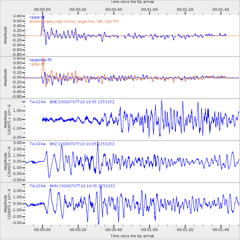
Signal To Noise
| Channel | StoN | STA | LTA |
| TA:U24A: :BHZ:20090707T19:19:05.225015Z | 11.323509 | 1.2238797E-6 | 1.0808308E-7 |
| TA:U24A: :BHN:20090707T19:19:05.225015Z | 6.861353 | 1.071001E-6 | 1.5609182E-7 |
| TA:U24A: :BHE:20090707T19:19:05.225015Z | 1.6700932 | 2.5116105E-7 | 1.5038745E-7 |
| Arrivals |
| Ps | 5.2 SECOND |
| PpPs | 14 SECOND |
| PsPs/PpSs | 20 SECOND |


