You are here: Home > Network List > CI - Caltech Regional Seismic Network Stations List
> Station IRM Iron Mountain Pumping Station, Eagle Mtn., CA, USA > Earthquake Result Viewer
IRM Iron Mountain Pumping Station, Eagle Mtn., CA, USA - Earthquake Result Viewer
| Earthquake location: |
Samoa Islands Region |
| Earthquake latitude/longitude: |
-16.6/-172.0 |
| Earthquake time(UTC): |
2006/09/28 (271) 06:22:09 GMT |
| Earthquake Depth: |
28 km |
| Earthquake Magnitude: |
6.5 MB, 6.6 MS, 6.9 MW, 6.7 MW |
| Earthquake Catalog/Contributor: |
WHDF/NEIC |
|
| Network: |
CI Caltech Regional Seismic Network |
| Station: |
IRM Iron Mountain Pumping Station, Eagle Mtn., CA, USA |
| Lat/Lon: |
34.16 N/115.15 W |
| Elevation: |
567 m |
|
| Distance: |
74.0 deg |
| Az: |
46.269 deg |
| Baz: |
236.675 deg |
| Ray Param: |
0.052595817 |
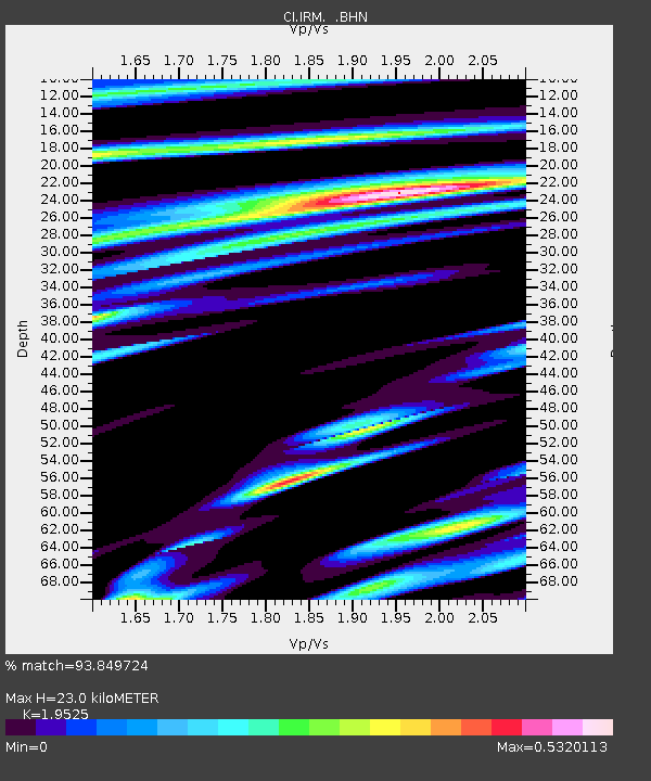
| Estimated Moho Depth: |
23.0 km |
| Estimated Crust Vp/Vs: |
1.95 |
| Assumed Crust Vp: |
6.276 km/s |
| Estimated Crust Vs: |
3.214 km/s |
| Estimated Crust Poisson's Ratio: |
0.32 |
|
| Radial Match: |
93.849724 % |
| Radial Bump: |
400 |
| Transverse Match: |
91.884224 % |
| Transverse Bump: |
400 |
| SOD ConfigId: |
2665 |
| Insert Time: |
2010-02-26 01:44:13.930 +0000 |
| GWidth: |
2.5 |
| Max Bumps: |
400 |
| Tol: |
0.001 |
|
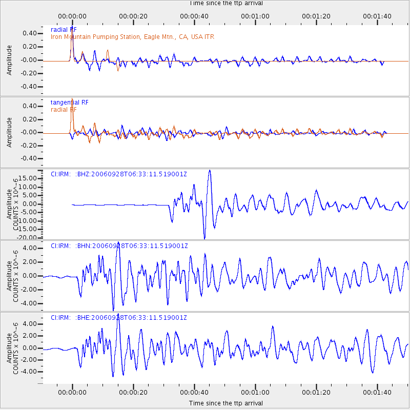
Signal To Noise
| Channel | StoN | STA | LTA |
| CI:IRM: :BHN:20060928T06:33:11.519001Z | 12.6748085 | 1.133907E-6 | 8.9461466E-8 |
| CI:IRM: :BHE:20060928T06:33:11.519001Z | 12.721547 | 1.2261561E-6 | 9.63842E-8 |
| CI:IRM: :BHZ:20060928T06:33:11.519001Z | 28.1801 | 3.764033E-6 | 1.3357061E-7 |
| Arrivals |
| Ps | 3.6 SECOND |
| PpPs | 11 SECOND |
| PsPs/PpSs | 14 SECOND |


