You are here: Home > Network List > TA - USArray Transportable Network (new EarthScope stations) Stations List
> Station U24A Moreno Valley High School, Angel Fire, NM, USA > Earthquake Result Viewer
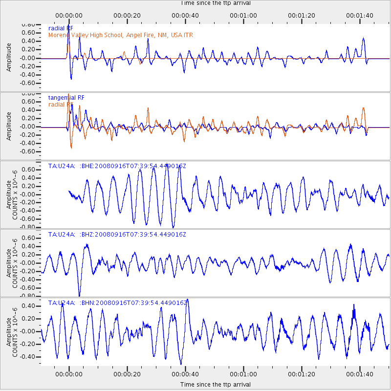
U24A Moreno Valley High School, Angel Fire, NM, USA - Earthquake Result Viewer
*The percent match for this event was below the threshold and hence no stack was calculated.
| Earthquake location: |
Central Mid-Atlantic Ridge |
| Earthquake latitude/longitude: |
0.9/-29.0 |
| Earthquake time(UTC): |
2008/09/16 (260) 07:28:25 GMT |
| Earthquake Depth: |
10 km |
| Earthquake Magnitude: |
5.8 MW, 5.2 MS, 5.2 MB, 5.8 MW |
| Earthquake Catalog/Contributor: |
WHDF/NEIC |
|
| Network: |
TA USArray Transportable Network (new EarthScope stations) |
| Station: |
U24A Moreno Valley High School, Angel Fire, NM, USA |
| Lat/Lon: |
36.41 N/105.28 W |
| Elevation: |
2573 m |
|
| Distance: |
78.4 deg |
| Az: |
306.877 deg |
| Baz: |
97.48 deg |
| Ray Param: |
$rayparam |
*The percent match for this event was below the threshold and hence was not used in the summary stack. |
|
| Radial Match: |
65.34972 % |
| Radial Bump: |
400 |
| Transverse Match: |
63.691216 % |
| Transverse Bump: |
378 |
| SOD ConfigId: |
2560 |
| Insert Time: |
2010-03-06 08:02:40.130 +0000 |
| GWidth: |
2.5 |
| Max Bumps: |
400 |
| Tol: |
0.001 |
|
Signal To Noise
| Channel | StoN | STA | LTA |
| TA:U24A: :BHZ:20080916T07:39:54.449016Z | 1.5163094 | 3.2244276E-7 | 2.1264971E-7 |
| TA:U24A: :BHN:20080916T07:39:54.449016Z | 0.8765595 | 2.197224E-7 | 2.5066456E-7 |
| TA:U24A: :BHE:20080916T07:39:54.449016Z | 1.6688923 | 5.034122E-7 | 3.016445E-7 |
| Arrivals |
| Ps | |
| PpPs | |
| PsPs/PpSs | |


