You are here: Home > Network List > TA - USArray Transportable Network (new EarthScope stations) Stations List
> Station E20K Nigu River, AK, USA > Earthquake Result Viewer
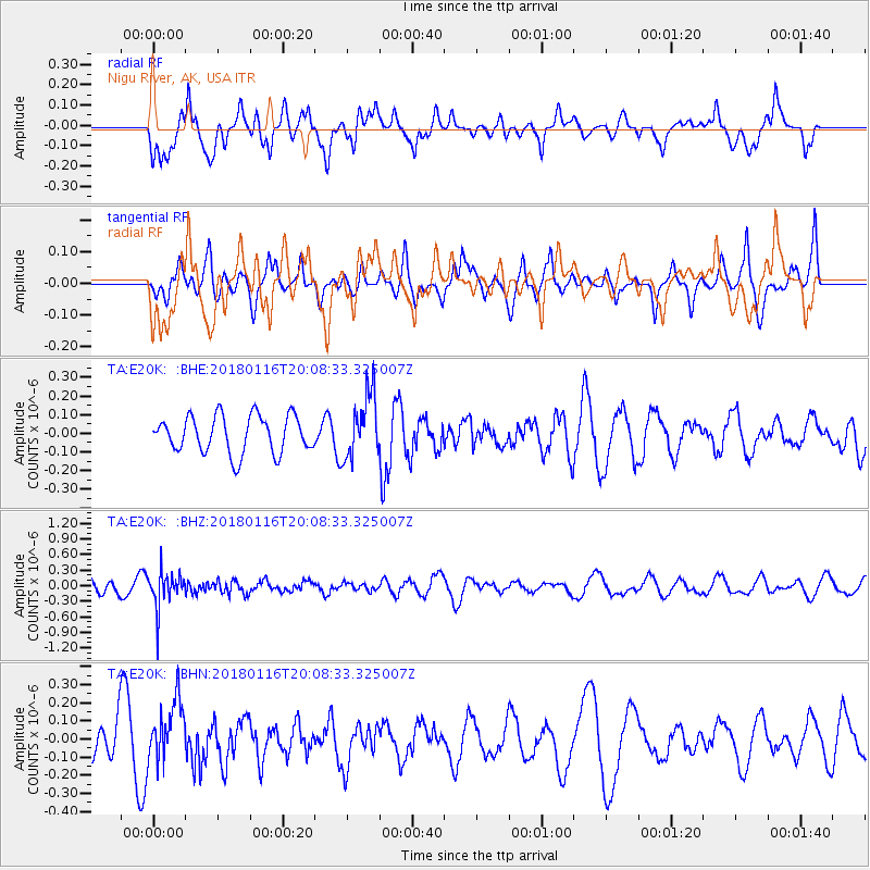
E20K Nigu River, AK, USA - Earthquake Result Viewer
*The percent match for this event was below the threshold and hence no stack was calculated.
| Earthquake location: |
Fiji Islands Region |
| Earthquake latitude/longitude: |
-19.5/-179.3 |
| Earthquake time(UTC): |
2018/01/16 (016) 19:57:18 GMT |
| Earthquake Depth: |
666 km |
| Earthquake Magnitude: |
5.9 Mww |
| Earthquake Catalog/Contributor: |
NEIC PDE/us |
|
| Network: |
TA USArray Transportable Network (new EarthScope stations) |
| Station: |
E20K Nigu River, AK, USA |
| Lat/Lon: |
68.26 N/156.19 W |
| Elevation: |
866 m |
|
| Distance: |
89.1 deg |
| Az: |
8.403 deg |
| Baz: |
201.722 deg |
| Ray Param: |
$rayparam |
*The percent match for this event was below the threshold and hence was not used in the summary stack. |
|
| Radial Match: |
56.88229 % |
| Radial Bump: |
400 |
| Transverse Match: |
48.349133 % |
| Transverse Bump: |
360 |
| SOD ConfigId: |
13570011 |
| Insert Time: |
2019-04-29 14:13:40.538 +0000 |
| GWidth: |
2.5 |
| Max Bumps: |
400 |
| Tol: |
0.001 |
|
Signal To Noise
| Channel | StoN | STA | LTA |
| TA:E20K: :BHZ:20180116T20:08:33.325007Z | 2.266159 | 3.4565815E-7 | 1.525304E-7 |
| TA:E20K: :BHN:20180116T20:08:33.325007Z | 1.0768498 | 1.6604302E-7 | 1.5419329E-7 |
| TA:E20K: :BHE:20180116T20:08:33.325007Z | 1.7056553 | 1.692595E-7 | 9.923429E-8 |
| Arrivals |
| Ps | |
| PpPs | |
| PsPs/PpSs | |


