You are here: Home > Network List > UU - University of Utah Regional Network Stations List
> Station NLU North Lily, UT, USA > Earthquake Result Viewer
NLU North Lily, UT, USA - Earthquake Result Viewer
| Earthquake location: |
Near Coast Of Ecuador |
| Earthquake latitude/longitude: |
0.4/-79.9 |
| Earthquake time(UTC): |
2016/04/16 (107) 23:58:37 GMT |
| Earthquake Depth: |
19 km |
| Earthquake Magnitude: |
7.8 MWW, 7.4 MI |
| Earthquake Catalog/Contributor: |
NEIC PDE/NEIC COMCAT |
|
| Network: |
UU University of Utah Regional Network |
| Station: |
NLU North Lily, UT, USA |
| Lat/Lon: |
39.95 N/112.07 W |
| Elevation: |
2036 m |
|
| Distance: |
49.1 deg |
| Az: |
327.241 deg |
| Baz: |
135.256 deg |
| Ray Param: |
0.06890893 |
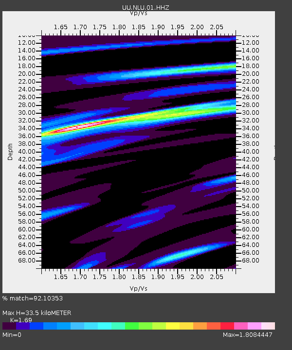
| Estimated Moho Depth: |
33.5 km |
| Estimated Crust Vp/Vs: |
1.69 |
| Assumed Crust Vp: |
6.276 km/s |
| Estimated Crust Vs: |
3.713 km/s |
| Estimated Crust Poisson's Ratio: |
0.23 |
|
| Radial Match: |
92.10353 % |
| Radial Bump: |
400 |
| Transverse Match: |
86.9101 % |
| Transverse Bump: |
400 |
| SOD ConfigId: |
1475611 |
| Insert Time: |
2016-05-01 00:23:53.319 +0000 |
| GWidth: |
2.5 |
| Max Bumps: |
400 |
| Tol: |
0.001 |
|

Signal To Noise
| Channel | StoN | STA | LTA |
| UU:NLU:01:HHZ:20160417T00:06:52.299989Z | 5.1921463 | 2.7525681E-8 | 5.3014073E-9 |
| UU:NLU:01:HHN:20160417T00:06:52.299989Z | 3.2319589 | 1.3412112E-8 | 4.14984E-9 |
| UU:NLU:01:HHE:20160417T00:06:52.299989Z | 1.4525872 | 9.8198685E-9 | 6.7602604E-9 |
| Arrivals |
| Ps | 3.9 SECOND |
| PpPs | 14 SECOND |
| PsPs/PpSs | 17 SECOND |


