You are here: Home > Network List > TA - USArray Transportable Network (new EarthScope stations) Stations List
> Station G23K Bananza Creek, AK, USA > Earthquake Result Viewer
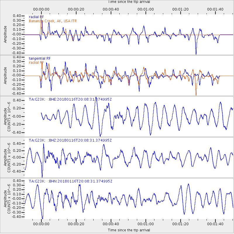
G23K Bananza Creek, AK, USA - Earthquake Result Viewer
*The percent match for this event was below the threshold and hence no stack was calculated.
| Earthquake location: |
Fiji Islands Region |
| Earthquake latitude/longitude: |
-19.5/-179.3 |
| Earthquake time(UTC): |
2018/01/16 (016) 19:57:18 GMT |
| Earthquake Depth: |
666 km |
| Earthquake Magnitude: |
5.9 Mww |
| Earthquake Catalog/Contributor: |
NEIC PDE/us |
|
| Network: |
TA USArray Transportable Network (new EarthScope stations) |
| Station: |
G23K Bananza Creek, AK, USA |
| Lat/Lon: |
66.71 N/150.02 W |
| Elevation: |
746 m |
|
| Distance: |
88.6 deg |
| Az: |
11.208 deg |
| Baz: |
207.469 deg |
| Ray Param: |
$rayparam |
*The percent match for this event was below the threshold and hence was not used in the summary stack. |
|
| Radial Match: |
61.91072 % |
| Radial Bump: |
400 |
| Transverse Match: |
70.59378 % |
| Transverse Bump: |
376 |
| SOD ConfigId: |
13570011 |
| Insert Time: |
2019-04-29 14:13:46.528 +0000 |
| GWidth: |
2.5 |
| Max Bumps: |
400 |
| Tol: |
0.001 |
|
Signal To Noise
| Channel | StoN | STA | LTA |
| TA:G23K: :BHZ:20180116T20:08:31.374995Z | 1.2828847 | 2.0926936E-7 | 1.6312406E-7 |
| TA:G23K: :BHN:20180116T20:08:31.374995Z | 1.4521599 | 2.0406175E-7 | 1.4052291E-7 |
| TA:G23K: :BHE:20180116T20:08:31.374995Z | 2.5615454 | 3.213774E-7 | 1.2546231E-7 |
| Arrivals |
| Ps | |
| PpPs | |
| PsPs/PpSs | |


