You are here: Home > Network List > AU - Australian Seismological Centre Stations List
> Station CTA Charters Towers, Queensland > Earthquake Result Viewer
CTA Charters Towers, Queensland - Earthquake Result Viewer
| Earthquake location: |
Kermadec Islands, New Zealand |
| Earthquake latitude/longitude: |
-30.1/-177.8 |
| Earthquake time(UTC): |
2018/01/17 (017) 22:56:58 GMT |
| Earthquake Depth: |
31 km |
| Earthquake Magnitude: |
5.8 mb |
| Earthquake Catalog/Contributor: |
NEIC PDE/us |
|
| Network: |
AU Australian Seismological Centre |
| Station: |
CTA Charters Towers, Queensland |
| Lat/Lon: |
20.09 S/146.25 E |
| Elevation: |
426 m |
|
| Distance: |
34.0 deg |
| Az: |
278.59 deg |
| Baz: |
114.247 deg |
| Ray Param: |
0.07792118 |
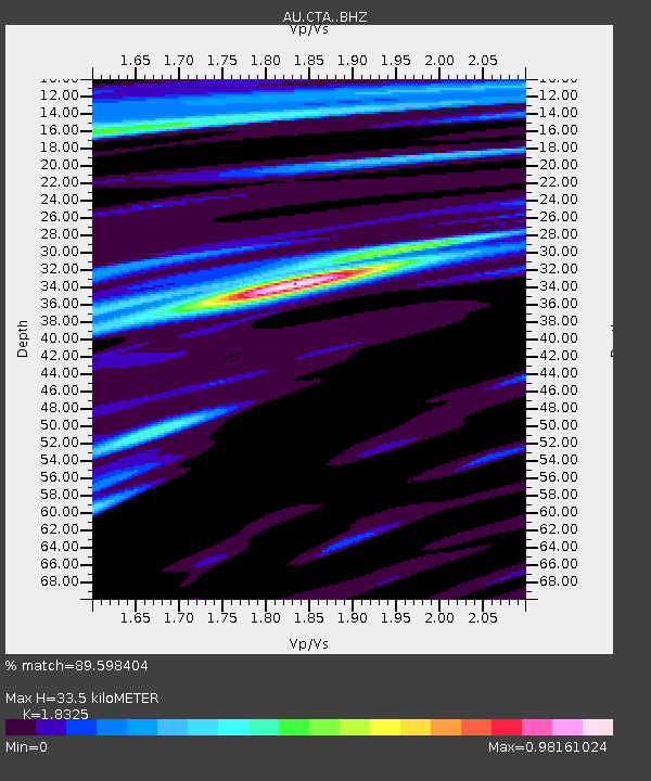
| Estimated Moho Depth: |
33.5 km |
| Estimated Crust Vp/Vs: |
1.83 |
| Assumed Crust Vp: |
6.522 km/s |
| Estimated Crust Vs: |
3.559 km/s |
| Estimated Crust Poisson's Ratio: |
0.29 |
|
| Radial Match: |
89.598404 % |
| Radial Bump: |
363 |
| Transverse Match: |
68.7189 % |
| Transverse Bump: |
400 |
| SOD ConfigId: |
13570011 |
| Insert Time: |
2019-04-29 14:16:49.846 +0000 |
| GWidth: |
2.5 |
| Max Bumps: |
400 |
| Tol: |
0.001 |
|

Signal To Noise
| Channel | StoN | STA | LTA |
| AU:CTA: :BHZ:20180117T23:03:08.599987Z | 14.580469 | 3.7597222E-6 | 2.5786017E-7 |
| AU:CTA: :BHN:20180117T23:03:08.599987Z | 2.8886852 | 7.103921E-7 | 2.4592228E-7 |
| AU:CTA: :BHE:20180117T23:03:08.599987Z | 17.018816 | 2.5344889E-6 | 1.4892275E-7 |
| Arrivals |
| Ps | 4.6 SECOND |
| PpPs | 13 SECOND |
| PsPs/PpSs | 18 SECOND |


