You are here: Home > Network List > TA - USArray Transportable Network (new EarthScope stations) Stations List
> Station WHTX Lake Whitney, Meridian, TX, USA > Earthquake Result Viewer
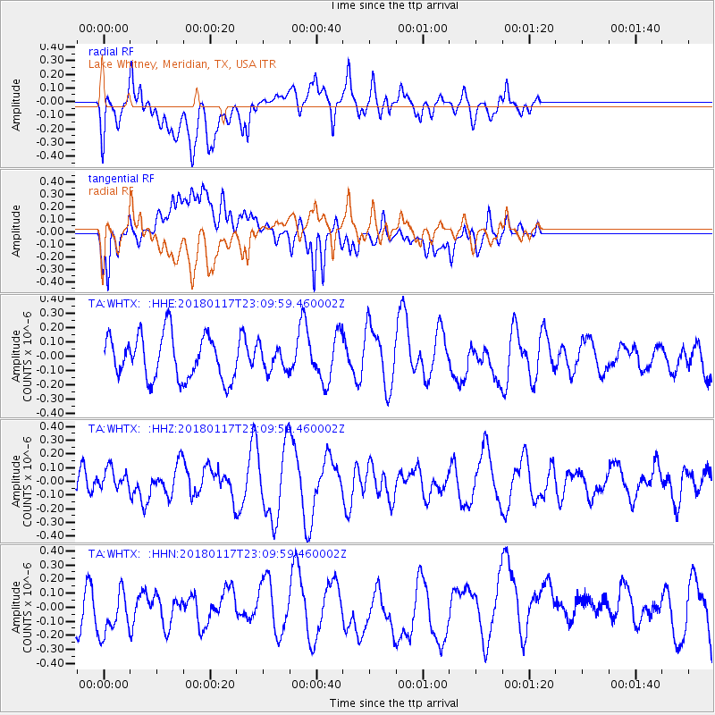
WHTX Lake Whitney, Meridian, TX, USA - Earthquake Result Viewer
*The percent match for this event was below the threshold and hence no stack was calculated.
| Earthquake location: |
Kermadec Islands, New Zealand |
| Earthquake latitude/longitude: |
-30.1/-177.8 |
| Earthquake time(UTC): |
2018/01/17 (017) 22:56:58 GMT |
| Earthquake Depth: |
31 km |
| Earthquake Magnitude: |
5.8 mb |
| Earthquake Catalog/Contributor: |
NEIC PDE/us |
|
| Network: |
TA USArray Transportable Network (new EarthScope stations) |
| Station: |
WHTX Lake Whitney, Meridian, TX, USA |
| Lat/Lon: |
31.99 N/97.46 W |
| Elevation: |
190 m |
|
| Distance: |
98.0 deg |
| Az: |
57.758 deg |
| Baz: |
239.623 deg |
| Ray Param: |
$rayparam |
*The percent match for this event was below the threshold and hence was not used in the summary stack. |
|
| Radial Match: |
62.735584 % |
| Radial Bump: |
400 |
| Transverse Match: |
59.230675 % |
| Transverse Bump: |
400 |
| SOD ConfigId: |
13570011 |
| Insert Time: |
2019-04-29 14:20:47.541 +0000 |
| GWidth: |
2.5 |
| Max Bumps: |
400 |
| Tol: |
0.001 |
|
Signal To Noise
| Channel | StoN | STA | LTA |
| TA:WHTX: :HHZ:20180117T23:09:59.460002Z | 0.51251143 | 7.727461E-8 | 1.5077637E-7 |
| TA:WHTX: :HHN:20180117T23:09:59.460002Z | 0.8901249 | 2.1824823E-7 | 2.4518832E-7 |
| TA:WHTX: :HHE:20180117T23:09:59.460002Z | 0.5257535 | 8.056843E-8 | 1.5324373E-7 |
| Arrivals |
| Ps | |
| PpPs | |
| PsPs/PpSs | |


