You are here: Home > Network List > TA - USArray Transportable Network (new EarthScope stations) Stations List
> Station U24A Moreno Valley High School, Angel Fire, NM, USA > Earthquake Result Viewer
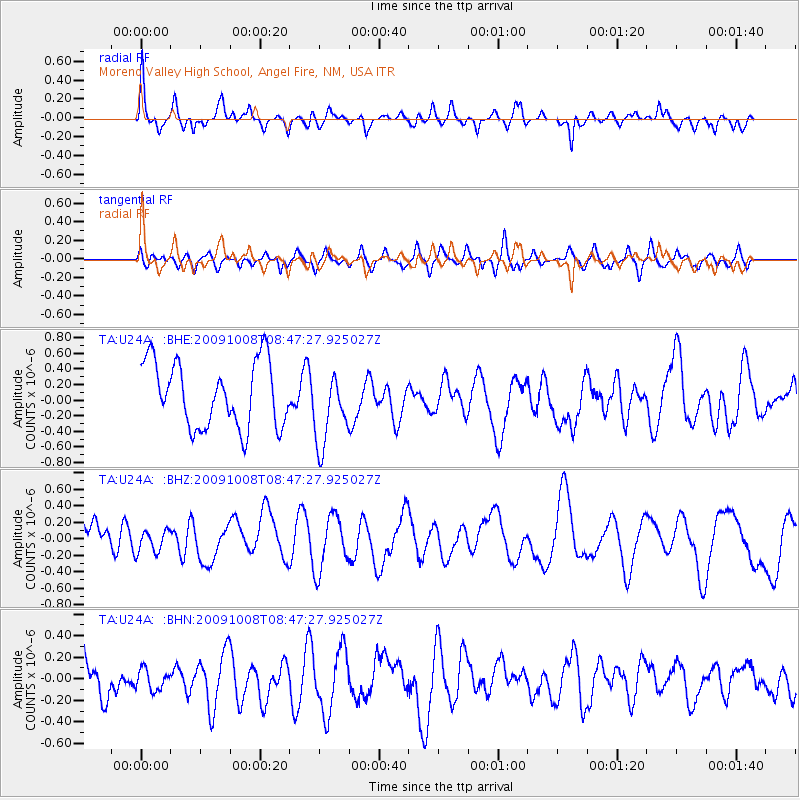
U24A Moreno Valley High School, Angel Fire, NM, USA - Earthquake Result Viewer
*The percent match for this event was below the threshold and hence no stack was calculated.
| Earthquake location: |
Santa Cruz Islands |
| Earthquake latitude/longitude: |
-12.2/166.5 |
| Earthquake time(UTC): |
2009/10/08 (281) 08:34:36 GMT |
| Earthquake Depth: |
35 km |
| Earthquake Magnitude: |
6.0 MB |
| Earthquake Catalog/Contributor: |
WHDF/NEIC |
|
| Network: |
TA USArray Transportable Network (new EarthScope stations) |
| Station: |
U24A Moreno Valley High School, Angel Fire, NM, USA |
| Lat/Lon: |
36.41 N/105.28 W |
| Elevation: |
2573 m |
|
| Distance: |
95.7 deg |
| Az: |
54.134 deg |
| Baz: |
259.126 deg |
| Ray Param: |
$rayparam |
*The percent match for this event was below the threshold and hence was not used in the summary stack. |
|
| Radial Match: |
71.13734 % |
| Radial Bump: |
356 |
| Transverse Match: |
52.85924 % |
| Transverse Bump: |
400 |
| SOD ConfigId: |
2622 |
| Insert Time: |
2010-03-06 08:03:39.779 +0000 |
| GWidth: |
2.5 |
| Max Bumps: |
400 |
| Tol: |
0.001 |
|
Signal To Noise
| Channel | StoN | STA | LTA |
| TA:U24A: :BHZ:20091008T08:47:27.925027Z | 0.41004378 | 1.4700879E-7 | 3.5851977E-7 |
| TA:U24A: :BHN:20091008T08:47:27.925027Z | 0.5699753 | 9.548112E-8 | 1.6751798E-7 |
| TA:U24A: :BHE:20091008T08:47:27.925027Z | 1.1299281 | 4.7031835E-7 | 4.1623738E-7 |
| Arrivals |
| Ps | |
| PpPs | |
| PsPs/PpSs | |


