You are here: Home > Network List > AK - Alaska Regional Network Stations List
> Station MDM Murphy Dome > Earthquake Result Viewer
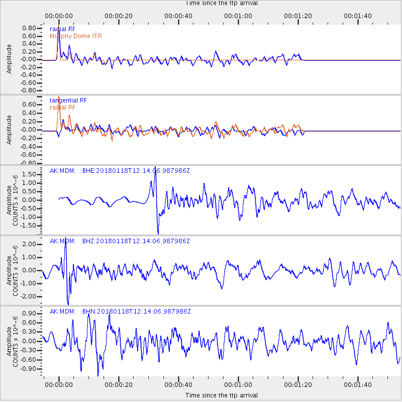
MDM Murphy Dome - Earthquake Result Viewer
*The percent match for this event was below the threshold and hence no stack was calculated.
| Earthquake location: |
Northwest Of Kuril Islands |
| Earthquake latitude/longitude: |
52.6/153.0 |
| Earthquake time(UTC): |
2018/01/18 (018) 12:08:52 GMT |
| Earthquake Depth: |
448 km |
| Earthquake Magnitude: |
5.7 Mww |
| Earthquake Catalog/Contributor: |
NEIC PDE/us |
|
| Network: |
AK Alaska Regional Network |
| Station: |
MDM Murphy Dome |
| Lat/Lon: |
64.96 N/148.23 W |
| Elevation: |
634 m |
|
| Distance: |
31.6 deg |
| Az: |
43.944 deg |
| Baz: |
275.568 deg |
| Ray Param: |
$rayparam |
*The percent match for this event was below the threshold and hence was not used in the summary stack. |
|
| Radial Match: |
63.390236 % |
| Radial Bump: |
400 |
| Transverse Match: |
40.12137 % |
| Transverse Bump: |
308 |
| SOD ConfigId: |
13570011 |
| Insert Time: |
2019-04-29 14:22:53.790 +0000 |
| GWidth: |
2.5 |
| Max Bumps: |
400 |
| Tol: |
0.001 |
|
Signal To Noise
| Channel | StoN | STA | LTA |
| AK:MDM: :BHZ:20180118T12:14:06.987986Z | 4.9761996 | 1.1652888E-6 | 2.3417245E-7 |
| AK:MDM: :BHN:20180118T12:14:06.987986Z | 1.1790555 | 2.6057364E-7 | 2.2100204E-7 |
| AK:MDM: :BHE:20180118T12:14:06.987986Z | 6.3451037 | 9.522643E-7 | 1.500786E-7 |
| Arrivals |
| Ps | |
| PpPs | |
| PsPs/PpSs | |


