You are here: Home > Network List > TA - USArray Transportable Network (new EarthScope stations) Stations List
> Station U24A Moreno Valley High School, Angel Fire, NM, USA > Earthquake Result Viewer
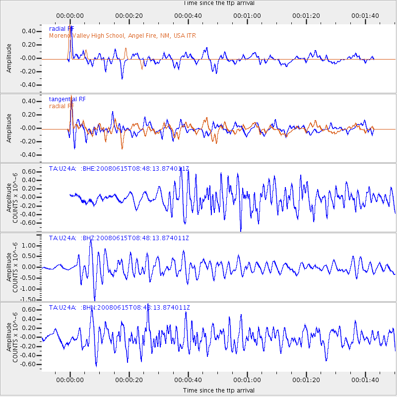
U24A Moreno Valley High School, Angel Fire, NM, USA - Earthquake Result Viewer
*The percent match for this event was below the threshold and hence no stack was calculated.
| Earthquake location: |
Southern East Pacific Rise |
| Earthquake latitude/longitude: |
-36.6/-107.4 |
| Earthquake time(UTC): |
2008/06/15 (167) 08:37:17 GMT |
| Earthquake Depth: |
10 km |
| Earthquake Magnitude: |
5.5 MB, 5.4 MS, 6.0 MW, 6.0 MW |
| Earthquake Catalog/Contributor: |
WHDF/NEIC |
|
| Network: |
TA USArray Transportable Network (new EarthScope stations) |
| Station: |
U24A Moreno Valley High School, Angel Fire, NM, USA |
| Lat/Lon: |
36.41 N/105.28 W |
| Elevation: |
2573 m |
|
| Distance: |
72.7 deg |
| Az: |
1.835 deg |
| Baz: |
181.83 deg |
| Ray Param: |
$rayparam |
*The percent match for this event was below the threshold and hence was not used in the summary stack. |
|
| Radial Match: |
77.86089 % |
| Radial Bump: |
400 |
| Transverse Match: |
75.07515 % |
| Transverse Bump: |
400 |
| SOD ConfigId: |
2504 |
| Insert Time: |
2010-03-06 08:04:11.653 +0000 |
| GWidth: |
2.5 |
| Max Bumps: |
400 |
| Tol: |
0.001 |
|
Signal To Noise
| Channel | StoN | STA | LTA |
| TA:U24A: :BHZ:20080615T08:48:13.874011Z | 3.2298195 | 2.9154842E-7 | 9.026771E-8 |
| TA:U24A: :BHN:20080615T08:48:13.874011Z | 1.1826911 | 1.3563769E-7 | 1.1468565E-7 |
| TA:U24A: :BHE:20080615T08:48:13.874011Z | 2.363668 | 2.0898185E-7 | 8.841421E-8 |
| Arrivals |
| Ps | |
| PpPs | |
| PsPs/PpSs | |


