You are here: Home > Network List > CI - Caltech Regional Seismic Network Stations List
> Station IRM Iron Mountain Pumping Station, Eagle Mtn., CA, USA > Earthquake Result Viewer
IRM Iron Mountain Pumping Station, Eagle Mtn., CA, USA - Earthquake Result Viewer
| Earthquake location: |
Near S. Coast Of Western Honshu |
| Earthquake latitude/longitude: |
33.1/136.6 |
| Earthquake time(UTC): |
2004/09/05 (249) 10:07:07 GMT |
| Earthquake Depth: |
14 km |
| Earthquake Magnitude: |
6.7 MB, 7.0 MS, 7.2 MW, 7.0 MW |
| Earthquake Catalog/Contributor: |
WHDF/NEIC |
|
| Network: |
CI Caltech Regional Seismic Network |
| Station: |
IRM Iron Mountain Pumping Station, Eagle Mtn., CA, USA |
| Lat/Lon: |
34.16 N/115.15 W |
| Elevation: |
567 m |
|
| Distance: |
85.1 deg |
| Az: |
52.232 deg |
| Baz: |
306.828 deg |
| Ray Param: |
0.045008708 |
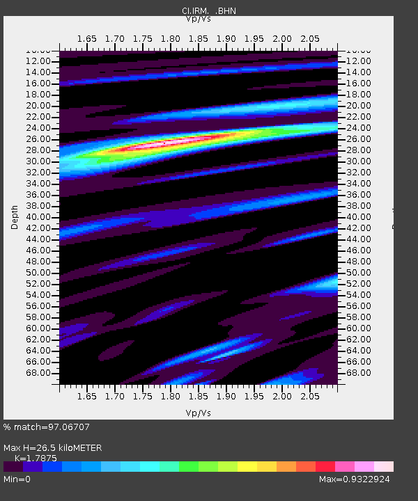
| Estimated Moho Depth: |
26.5 km |
| Estimated Crust Vp/Vs: |
1.79 |
| Assumed Crust Vp: |
6.276 km/s |
| Estimated Crust Vs: |
3.511 km/s |
| Estimated Crust Poisson's Ratio: |
0.27 |
|
| Radial Match: |
97.06707 % |
| Radial Bump: |
400 |
| Transverse Match: |
94.335 % |
| Transverse Bump: |
400 |
| SOD ConfigId: |
2459 |
| Insert Time: |
2010-02-26 01:44:17.740 +0000 |
| GWidth: |
2.5 |
| Max Bumps: |
400 |
| Tol: |
0.001 |
|
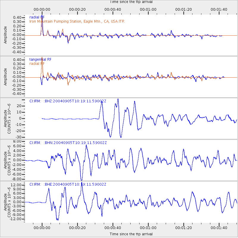
Signal To Noise
| Channel | StoN | STA | LTA |
| CI:IRM: :BHN:20040905T10:19:11.59002Z | 4.741348 | 1.3974682E-6 | 2.9474072E-7 |
| CI:IRM: :BHE:20040905T10:19:11.59002Z | 12.796852 | 4.024767E-6 | 3.1451225E-7 |
| CI:IRM: :BHZ:20040905T10:19:11.59002Z | 42.628555 | 1.1810235E-5 | 2.7704988E-7 |
| Arrivals |
| Ps | 3.4 SECOND |
| PpPs | 12 SECOND |
| PsPs/PpSs | 15 SECOND |


