You are here: Home > Network List > TA - USArray Transportable Network (new EarthScope stations) Stations List
> Station G31M Satah River, YT, CAN > Earthquake Result Viewer
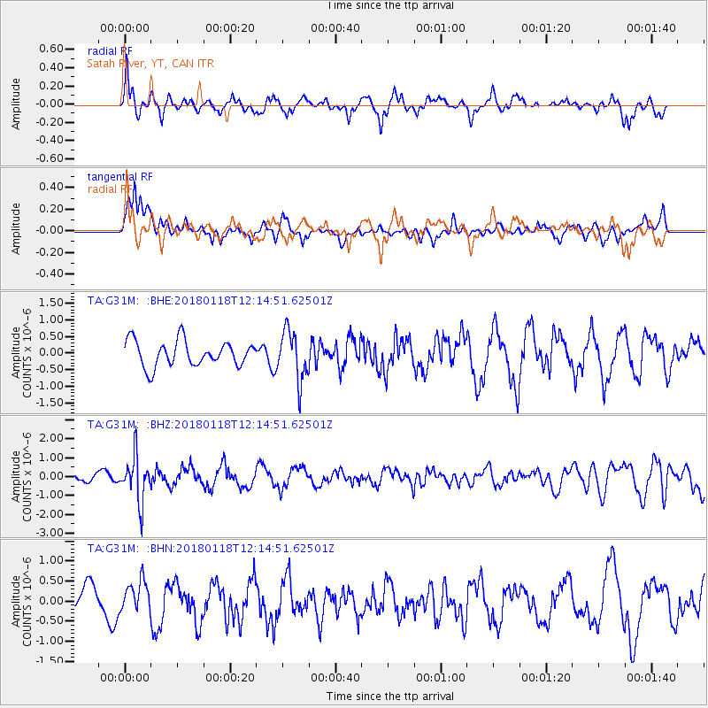
G31M Satah River, YT, CAN - Earthquake Result Viewer
*The percent match for this event was below the threshold and hence no stack was calculated.
| Earthquake location: |
Northwest Of Kuril Islands |
| Earthquake latitude/longitude: |
52.6/153.0 |
| Earthquake time(UTC): |
2018/01/18 (018) 12:08:52 GMT |
| Earthquake Depth: |
448 km |
| Earthquake Magnitude: |
5.7 Mww |
| Earthquake Catalog/Contributor: |
NEIC PDE/us |
|
| Network: |
TA USArray Transportable Network (new EarthScope stations) |
| Station: |
G31M Satah River, YT, CAN |
| Lat/Lon: |
66.92 N/134.27 W |
| Elevation: |
61 m |
|
| Distance: |
36.9 deg |
| Az: |
38.791 deg |
| Baz: |
284.049 deg |
| Ray Param: |
$rayparam |
*The percent match for this event was below the threshold and hence was not used in the summary stack. |
|
| Radial Match: |
61.607323 % |
| Radial Bump: |
368 |
| Transverse Match: |
55.267056 % |
| Transverse Bump: |
377 |
| SOD ConfigId: |
13570011 |
| Insert Time: |
2019-04-29 14:29:34.102 +0000 |
| GWidth: |
2.5 |
| Max Bumps: |
400 |
| Tol: |
0.001 |
|
Signal To Noise
| Channel | StoN | STA | LTA |
| TA:G31M: :BHZ:20180118T12:14:51.62501Z | 4.3450475 | 1.192799E-6 | 2.7451918E-7 |
| TA:G31M: :BHN:20180118T12:14:51.62501Z | 0.8562059 | 3.9373305E-7 | 4.5985792E-7 |
| TA:G31M: :BHE:20180118T12:14:51.62501Z | 1.9639486 | 7.482621E-7 | 3.809988E-7 |
| Arrivals |
| Ps | |
| PpPs | |
| PsPs/PpSs | |


