You are here: Home > Network List > TA - USArray Transportable Network (new EarthScope stations) Stations List
> Station I23K Minto, Yukon-Koyukuk, AK, USA > Earthquake Result Viewer
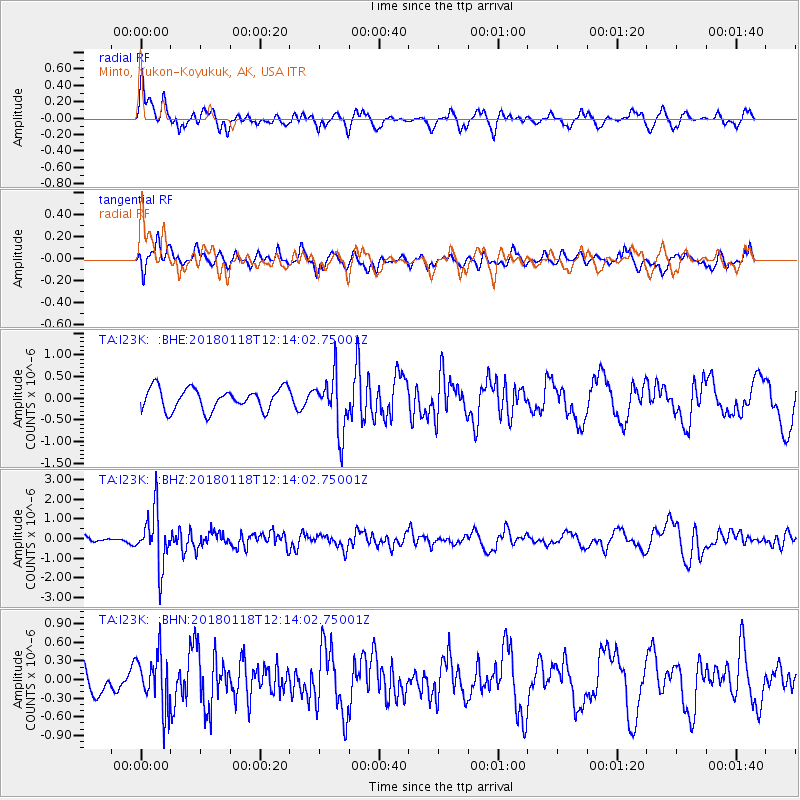
I23K Minto, Yukon-Koyukuk, AK, USA - Earthquake Result Viewer
*The percent match for this event was below the threshold and hence no stack was calculated.
| Earthquake location: |
Northwest Of Kuril Islands |
| Earthquake latitude/longitude: |
52.6/153.0 |
| Earthquake time(UTC): |
2018/01/18 (018) 12:08:52 GMT |
| Earthquake Depth: |
448 km |
| Earthquake Magnitude: |
5.7 Mww |
| Earthquake Catalog/Contributor: |
NEIC PDE/us |
|
| Network: |
TA USArray Transportable Network (new EarthScope stations) |
| Station: |
I23K Minto, Yukon-Koyukuk, AK, USA |
| Lat/Lon: |
65.15 N/149.36 W |
| Elevation: |
149 m |
|
| Distance: |
31.1 deg |
| Az: |
43.66 deg |
| Baz: |
274.301 deg |
| Ray Param: |
$rayparam |
*The percent match for this event was below the threshold and hence was not used in the summary stack. |
|
| Radial Match: |
73.12642 % |
| Radial Bump: |
352 |
| Transverse Match: |
58.38317 % |
| Transverse Bump: |
346 |
| SOD ConfigId: |
13570011 |
| Insert Time: |
2019-04-29 14:29:39.907 +0000 |
| GWidth: |
2.5 |
| Max Bumps: |
400 |
| Tol: |
0.001 |
|
Signal To Noise
| Channel | StoN | STA | LTA |
| TA:I23K: :BHZ:20180118T12:14:02.75001Z | 7.3221116 | 1.3698158E-6 | 1.8707934E-7 |
| TA:I23K: :BHN:20180118T12:14:02.75001Z | 1.3432775 | 4.2371545E-7 | 3.1543405E-7 |
| TA:I23K: :BHE:20180118T12:14:02.75001Z | 2.6104226 | 6.5072845E-7 | 2.4928087E-7 |
| Arrivals |
| Ps | |
| PpPs | |
| PsPs/PpSs | |


