You are here: Home > Network List > TA - USArray Transportable Network (new EarthScope stations) Stations List
> Station MDND Maddock, ND, USA > Earthquake Result Viewer
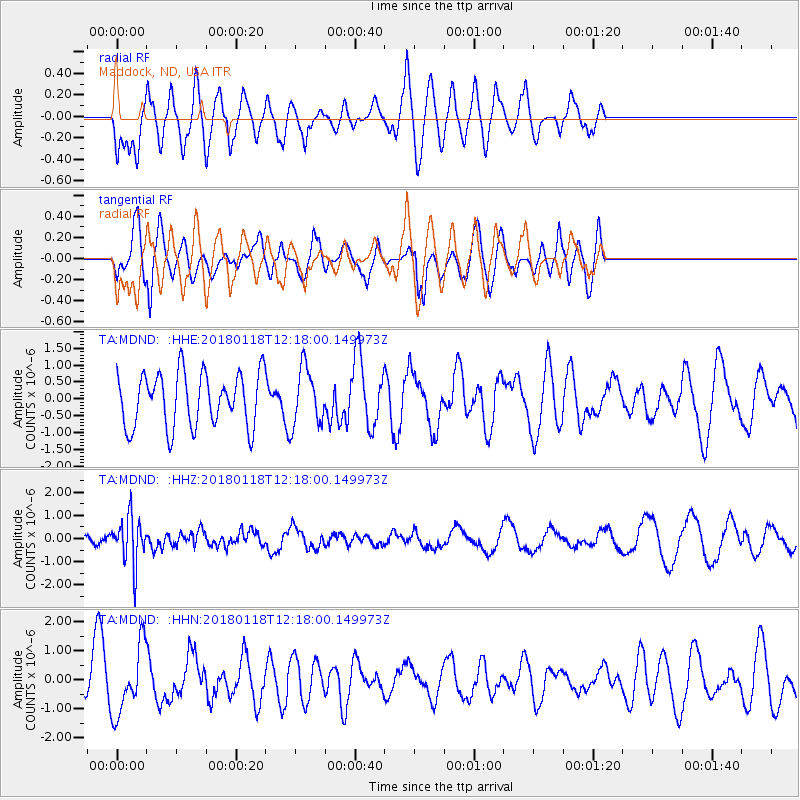
MDND Maddock, ND, USA - Earthquake Result Viewer
*The percent match for this event was below the threshold and hence no stack was calculated.
| Earthquake location: |
Northwest Of Kuril Islands |
| Earthquake latitude/longitude: |
52.6/153.0 |
| Earthquake time(UTC): |
2018/01/18 (018) 12:08:52 GMT |
| Earthquake Depth: |
448 km |
| Earthquake Magnitude: |
5.7 Mww |
| Earthquake Catalog/Contributor: |
NEIC PDE/us |
|
| Network: |
TA USArray Transportable Network (new EarthScope stations) |
| Station: |
MDND Maddock, ND, USA |
| Lat/Lon: |
47.85 N/99.60 W |
| Elevation: |
479 m |
|
| Distance: |
62.5 deg |
| Az: |
46.454 deg |
| Baz: |
318.939 deg |
| Ray Param: |
$rayparam |
*The percent match for this event was below the threshold and hence was not used in the summary stack. |
|
| Radial Match: |
67.23256 % |
| Radial Bump: |
400 |
| Transverse Match: |
59.248615 % |
| Transverse Bump: |
375 |
| SOD ConfigId: |
13570011 |
| Insert Time: |
2019-04-29 14:29:59.853 +0000 |
| GWidth: |
2.5 |
| Max Bumps: |
400 |
| Tol: |
0.001 |
|
Signal To Noise
| Channel | StoN | STA | LTA |
| TA:MDND: :HHZ:20180118T12:18:00.149973Z | 2.648619 | 1.0108328E-6 | 3.8164524E-7 |
| TA:MDND: :HHN:20180118T12:18:00.149973Z | 1.6775892 | 1.1592307E-6 | 6.910099E-7 |
| TA:MDND: :HHE:20180118T12:18:00.149973Z | 1.0802989 | 8.6153364E-7 | 7.974956E-7 |
| Arrivals |
| Ps | |
| PpPs | |
| PsPs/PpSs | |


