You are here: Home > Network List > TA - USArray Transportable Network (new EarthScope stations) Stations List
> Station R24A Sanders Place, Florence, CO, USA > Earthquake Result Viewer
R24A Sanders Place, Florence, CO, USA - Earthquake Result Viewer

| Earthquake location: |
Easter Island Region |
| Earthquake latitude/longitude: |
-28.5/-112.8 |
| Earthquake time(UTC): |
2008/08/19 (232) 10:58:00 GMT |
| Earthquake Depth: |
9.0 km |
| Earthquake Magnitude: |
5.5 MB, 5.3 MS, 5.7 MW, 5.7 MW |
| Earthquake Catalog/Contributor: |
WHDF/NEIC |
|
| Network: |
TA USArray Transportable Network (new EarthScope stations) |
| Station: |
R24A Sanders Place, Florence, CO, USA |
| Lat/Lon: |
38.23 N/105.11 W |
| Elevation: |
1978 m |
|
| Distance: |
66.8 deg |
| Az: |
6.621 deg |
| Baz: |
187.4 deg |
| Ray Param: |
0.05736343 |
| Estimated Moho Depth: |
30.5 km |
| Estimated Crust Vp/Vs: |
1.67 |
| Assumed Crust Vp: |
6.159 km/s |
| Estimated Crust Vs: |
3.682 km/s |
| Estimated Crust Poisson's Ratio: |
0.22 |
|
| Radial Match: |
82.98617 % |
| Radial Bump: |
318 |
| Transverse Match: |
71.88928 % |
| Transverse Bump: |
347 |
| SOD ConfigId: |
2504 |
| Insert Time: |
2010-03-06 08:04:46.641 +0000 |
| GWidth: |
2.5 |
| Max Bumps: |
400 |
| Tol: |
0.001 |
|
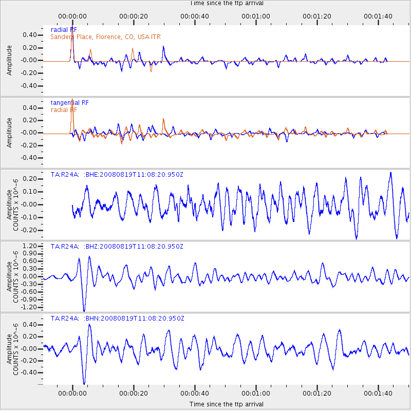
Signal To Noise
| Channel | StoN | STA | LTA |
| TA:R24A: :BHZ:20080819T11:08:20.950Z | 8.273886 | 5.782241E-7 | 6.988543E-8 |
| TA:R24A: :BHN:20080819T11:08:20.950Z | 4.745695 | 2.4040182E-7 | 5.065682E-8 |
| TA:R24A: :BHE:20080819T11:08:20.950Z | 1.1154954 | 6.743441E-8 | 6.045243E-8 |
| Arrivals |
| Ps | 3.5 SECOND |
| PpPs | 13 SECOND |
| PsPs/PpSs | 16 SECOND |


