You are here: Home > Network List > TA - USArray Transportable Network (new EarthScope stations) Stations List
> Station WHTX Lake Whitney, Meridian, TX, USA > Earthquake Result Viewer
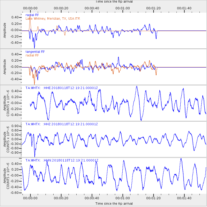
WHTX Lake Whitney, Meridian, TX, USA - Earthquake Result Viewer
*The percent match for this event was below the threshold and hence no stack was calculated.
| Earthquake location: |
Northwest Of Kuril Islands |
| Earthquake latitude/longitude: |
52.6/153.0 |
| Earthquake time(UTC): |
2018/01/18 (018) 12:08:52 GMT |
| Earthquake Depth: |
448 km |
| Earthquake Magnitude: |
5.7 Mww |
| Earthquake Catalog/Contributor: |
NEIC PDE/us |
|
| Network: |
TA USArray Transportable Network (new EarthScope stations) |
| Station: |
WHTX Lake Whitney, Meridian, TX, USA |
| Lat/Lon: |
31.99 N/97.46 W |
| Elevation: |
190 m |
|
| Distance: |
75.9 deg |
| Az: |
55.649 deg |
| Baz: |
323.623 deg |
| Ray Param: |
$rayparam |
*The percent match for this event was below the threshold and hence was not used in the summary stack. |
|
| Radial Match: |
68.76018 % |
| Radial Bump: |
400 |
| Transverse Match: |
57.20611 % |
| Transverse Bump: |
400 |
| SOD ConfigId: |
13570011 |
| Insert Time: |
2019-04-29 14:30:11.059 +0000 |
| GWidth: |
2.5 |
| Max Bumps: |
400 |
| Tol: |
0.001 |
|
Signal To Noise
| Channel | StoN | STA | LTA |
| TA:WHTX: :HHZ:20180118T12:19:21.00001Z | 1.6716303 | 4.6248368E-7 | 2.7666624E-7 |
| TA:WHTX: :HHN:20180118T12:19:21.00001Z | 0.80342275 | 2.2886145E-7 | 2.8485806E-7 |
| TA:WHTX: :HHE:20180118T12:19:21.00001Z | 0.73280865 | 1.5234151E-7 | 2.0788717E-7 |
| Arrivals |
| Ps | |
| PpPs | |
| PsPs/PpSs | |


