You are here: Home > Network List > TA - USArray Transportable Network (new EarthScope stations) Stations List
> Station R24A Sanders Place, Florence, CO, USA > Earthquake Result Viewer
R24A Sanders Place, Florence, CO, USA - Earthquake Result Viewer
| Earthquake location: |
Peru-Brazil Border Region |
| Earthquake latitude/longitude: |
-7.6/-74.4 |
| Earthquake time(UTC): |
2008/08/26 (239) 21:00:36 GMT |
| Earthquake Depth: |
154 km |
| Earthquake Magnitude: |
6.0 MB, 6.4 MW, 6.4 MW |
| Earthquake Catalog/Contributor: |
WHDF/NEIC |
|
| Network: |
TA USArray Transportable Network (new EarthScope stations) |
| Station: |
R24A Sanders Place, Florence, CO, USA |
| Lat/Lon: |
38.23 N/105.11 W |
| Elevation: |
1978 m |
|
| Distance: |
53.9 deg |
| Az: |
330.116 deg |
| Baz: |
141.162 deg |
| Ray Param: |
0.065310426 |
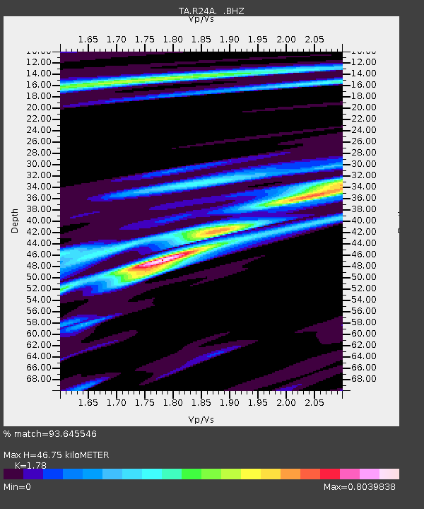
| Estimated Moho Depth: |
46.75 km |
| Estimated Crust Vp/Vs: |
1.78 |
| Assumed Crust Vp: |
6.159 km/s |
| Estimated Crust Vs: |
3.46 km/s |
| Estimated Crust Poisson's Ratio: |
0.27 |
|
| Radial Match: |
93.645546 % |
| Radial Bump: |
263 |
| Transverse Match: |
70.58243 % |
| Transverse Bump: |
400 |
| SOD ConfigId: |
2504 |
| Insert Time: |
2010-03-06 08:04:51.948 +0000 |
| GWidth: |
2.5 |
| Max Bumps: |
400 |
| Tol: |
0.001 |
|

Signal To Noise
| Channel | StoN | STA | LTA |
| TA:R24A: :BHZ:20080826T21:09:13.200027Z | 19.959183 | 1.5008587E-6 | 7.51964E-8 |
| TA:R24A: :BHN:20080826T21:09:13.200027Z | 7.632059 | 5.4745215E-7 | 7.17306E-8 |
| TA:R24A: :BHE:20080826T21:09:13.200027Z | 7.5659876 | 4.4426451E-7 | 5.8718644E-8 |
| Arrivals |
| Ps | 6.2 SECOND |
| PpPs | 20 SECOND |
| PsPs/PpSs | 26 SECOND |


