You are here: Home > Network List > TA - USArray Transportable Network (new EarthScope stations) Stations List
> Station R24A Sanders Place, Florence, CO, USA > Earthquake Result Viewer
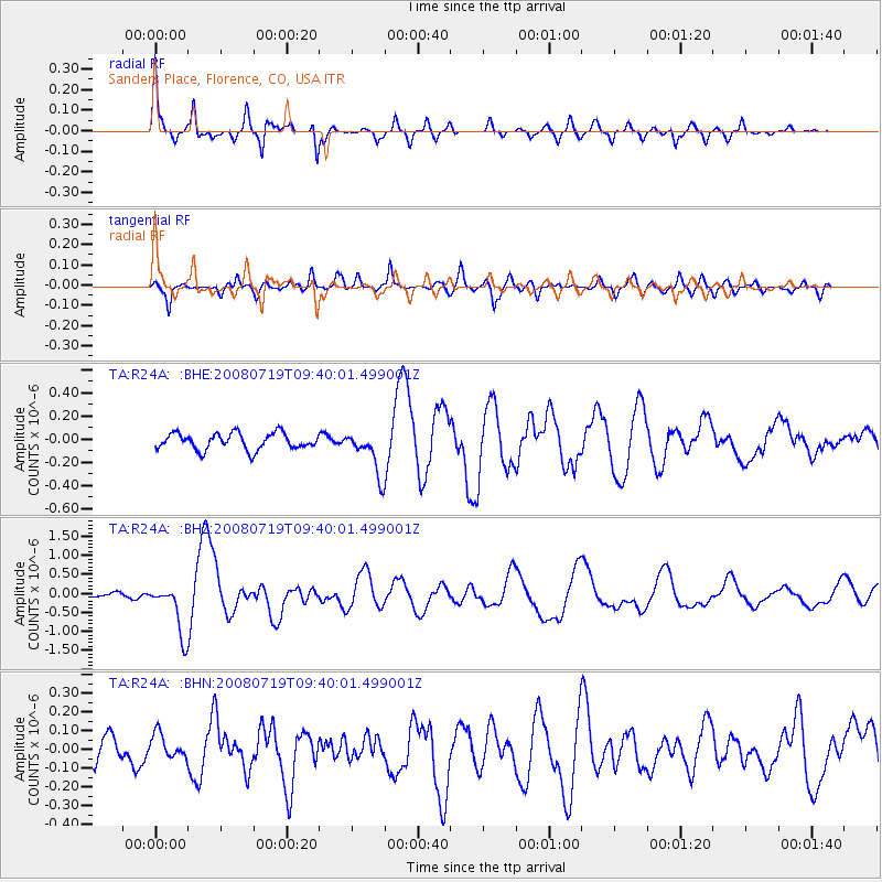
R24A Sanders Place, Florence, CO, USA - Earthquake Result Viewer

| Earthquake location: |
Santa Cruz Islands Region |
| Earthquake latitude/longitude: |
-11.0/164.5 |
| Earthquake time(UTC): |
2008/07/19 (201) 09:27:01 GMT |
| Earthquake Depth: |
11 km |
| Earthquake Magnitude: |
6.1 MB, 6.4 MS, 6.6 MW, 6.6 MW |
| Earthquake Catalog/Contributor: |
WHDF/NEIC |
|
| Network: |
TA USArray Transportable Network (new EarthScope stations) |
| Station: |
R24A Sanders Place, Florence, CO, USA |
| Lat/Lon: |
38.23 N/105.11 W |
| Elevation: |
1978 m |
|
| Distance: |
97.0 deg |
| Az: |
52.514 deg |
| Baz: |
261.562 deg |
| Ray Param: |
0.04033204 |
| Estimated Moho Depth: |
40.75 km |
| Estimated Crust Vp/Vs: |
1.89 |
| Assumed Crust Vp: |
6.159 km/s |
| Estimated Crust Vs: |
3.263 km/s |
| Estimated Crust Poisson's Ratio: |
0.30 |
|
| Radial Match: |
90.445816 % |
| Radial Bump: |
354 |
| Transverse Match: |
70.317314 % |
| Transverse Bump: |
400 |
| SOD ConfigId: |
2658 |
| Insert Time: |
2010-03-06 08:05:10.415 +0000 |
| GWidth: |
2.5 |
| Max Bumps: |
400 |
| Tol: |
0.001 |
|
Signal To Noise
| Channel | StoN | STA | LTA |
| TA:R24A: :BHZ:20080719T09:40:01.499001Z | 9.613072 | 6.784595E-7 | 7.057677E-8 |
| TA:R24A: :BHN:20080719T09:40:01.499001Z | 0.7678735 | 6.625316E-8 | 8.628135E-8 |
| TA:R24A: :BHE:20080719T09:40:01.499001Z | 2.712354 | 1.911358E-7 | 7.04686E-8 |
| Arrivals |
| Ps | 6.0 SECOND |
| PpPs | 19 SECOND |
| PsPs/PpSs | 25 SECOND |


