You are here: Home > Network List > TA - USArray Transportable Network (new EarthScope stations) Stations List
> Station R24A Sanders Place, Florence, CO, USA > Earthquake Result Viewer
R24A Sanders Place, Florence, CO, USA - Earthquake Result Viewer
| Earthquake location: |
Kermadec Islands Region |
| Earthquake latitude/longitude: |
-27.4/-176.3 |
| Earthquake time(UTC): |
2009/02/18 (049) 21:53:45 GMT |
| Earthquake Depth: |
25 km |
| Earthquake Magnitude: |
6.8 MB, 7.2 MS, 6.9 MW, 6.9 MW |
| Earthquake Catalog/Contributor: |
WHDF/NEIC |
|
| Network: |
TA USArray Transportable Network (new EarthScope stations) |
| Station: |
R24A Sanders Place, Florence, CO, USA |
| Lat/Lon: |
38.23 N/105.11 W |
| Elevation: |
1978 m |
|
| Distance: |
93.3 deg |
| Az: |
48.317 deg |
| Baz: |
237.452 deg |
| Ray Param: |
0.041287452 |
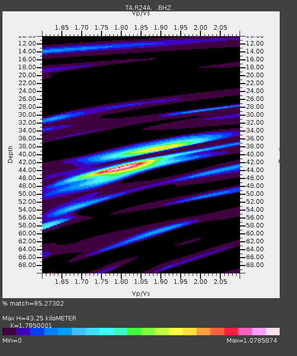
| Estimated Moho Depth: |
43.25 km |
| Estimated Crust Vp/Vs: |
1.80 |
| Assumed Crust Vp: |
6.159 km/s |
| Estimated Crust Vs: |
3.431 km/s |
| Estimated Crust Poisson's Ratio: |
0.27 |
|
| Radial Match: |
95.27302 % |
| Radial Bump: |
331 |
| Transverse Match: |
88.00757 % |
| Transverse Bump: |
400 |
| SOD ConfigId: |
2658 |
| Insert Time: |
2010-03-06 08:05:17.117 +0000 |
| GWidth: |
2.5 |
| Max Bumps: |
400 |
| Tol: |
0.001 |
|

Signal To Noise
| Channel | StoN | STA | LTA |
| TA:R24A: :BHZ:20090218T22:06:26.024014Z | 7.1894636 | 1.3842015E-6 | 1.9253196E-7 |
| TA:R24A: :BHN:20090218T22:06:26.024014Z | 2.1992168 | 5.3225756E-7 | 2.420214E-7 |
| TA:R24A: :BHE:20090218T22:06:26.024014Z | 2.671286 | 6.1596097E-7 | 2.3058591E-7 |
| Arrivals |
| Ps | 5.7 SECOND |
| PpPs | 19 SECOND |
| PsPs/PpSs | 25 SECOND |


