You are here: Home > Network List > TA - USArray Transportable Network (new EarthScope stations) Stations List
> Station K15K Wolf Creek Mountain, AK, USA > Earthquake Result Viewer
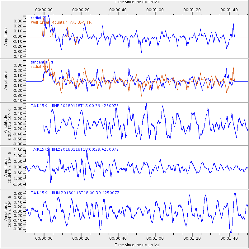
K15K Wolf Creek Mountain, AK, USA - Earthquake Result Viewer
*The percent match for this event was below the threshold and hence no stack was calculated.
| Earthquake location: |
Tanimbar Islands Reg., Indonesia |
| Earthquake latitude/longitude: |
-6.4/132.8 |
| Earthquake time(UTC): |
2018/01/18 (018) 17:48:39 GMT |
| Earthquake Depth: |
27 km |
| Earthquake Magnitude: |
5.6 Mww |
| Earthquake Catalog/Contributor: |
NEIC PDE/us |
|
| Network: |
TA USArray Transportable Network (new EarthScope stations) |
| Station: |
K15K Wolf Creek Mountain, AK, USA |
| Lat/Lon: |
62.29 N/161.53 W |
| Elevation: |
346 m |
|
| Distance: |
84.6 deg |
| Az: |
25.324 deg |
| Baz: |
245.441 deg |
| Ray Param: |
$rayparam |
*The percent match for this event was below the threshold and hence was not used in the summary stack. |
|
| Radial Match: |
48.92348 % |
| Radial Bump: |
400 |
| Transverse Match: |
68.812775 % |
| Transverse Bump: |
400 |
| SOD ConfigId: |
13570011 |
| Insert Time: |
2019-04-29 14:34:18.063 +0000 |
| GWidth: |
2.5 |
| Max Bumps: |
400 |
| Tol: |
0.001 |
|
Signal To Noise
| Channel | StoN | STA | LTA |
| TA:K15K: :BHZ:20180118T18:00:39.425007Z | 3.6010203 | 7.7441393E-7 | 2.1505403E-7 |
| TA:K15K: :BHN:20180118T18:00:39.425007Z | 1.0488219 | 3.187891E-7 | 3.039497E-7 |
| TA:K15K: :BHE:20180118T18:00:39.425007Z | 0.7573045 | 2.1070144E-7 | 2.7822554E-7 |
| Arrivals |
| Ps | |
| PpPs | |
| PsPs/PpSs | |


