You are here: Home > Network List > TA - USArray Transportable Network (new EarthScope stations) Stations List
> Station R24A Sanders Place, Florence, CO, USA > Earthquake Result Viewer
R24A Sanders Place, Florence, CO, USA - Earthquake Result Viewer
| Earthquake location: |
Samoa Islands Region |
| Earthquake latitude/longitude: |
-15.9/-171.7 |
| Earthquake time(UTC): |
2009/09/29 (272) 18:19:35 GMT |
| Earthquake Depth: |
10 km |
| Earthquake Magnitude: |
5.6 MB |
| Earthquake Catalog/Contributor: |
WHDF/NEIC |
|
| Network: |
TA USArray Transportable Network (new EarthScope stations) |
| Station: |
R24A Sanders Place, Florence, CO, USA |
| Lat/Lon: |
38.23 N/105.11 W |
| Elevation: |
1978 m |
|
| Distance: |
82.3 deg |
| Az: |
46.803 deg |
| Baz: |
242.941 deg |
| Ray Param: |
0.046953224 |
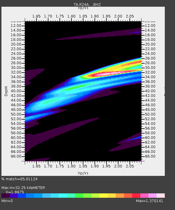
| Estimated Moho Depth: |
32.25 km |
| Estimated Crust Vp/Vs: |
1.97 |
| Assumed Crust Vp: |
6.159 km/s |
| Estimated Crust Vs: |
3.13 km/s |
| Estimated Crust Poisson's Ratio: |
0.33 |
|
| Radial Match: |
85.81124 % |
| Radial Bump: |
400 |
| Transverse Match: |
52.76039 % |
| Transverse Bump: |
400 |
| SOD ConfigId: |
2622 |
| Insert Time: |
2010-03-06 08:05:35.799 +0000 |
| GWidth: |
2.5 |
| Max Bumps: |
400 |
| Tol: |
0.001 |
|

Signal To Noise
| Channel | StoN | STA | LTA |
| TA:R24A: :BHZ:20090929T18:31:26.324021Z | 1.1169914 | 5.1136532E-5 | 4.5780598E-5 |
| TA:R24A: :BHN:20090929T18:31:26.324021Z | 2.053367 | 4.997966E-5 | 2.4340345E-5 |
| TA:R24A: :BHE:20090929T18:31:26.324021Z | 1.8585287 | 5.720844E-5 | 3.078157E-5 |
| Arrivals |
| Ps | 5.2 SECOND |
| PpPs | 15 SECOND |
| PsPs/PpSs | 20 SECOND |


