You are here: Home > Network List > EC - Ecuador Seismic Network Stations List
> Station MCRA RENSIG, RENAC > Earthquake Result Viewer
MCRA RENSIG, RENAC - Earthquake Result Viewer
| Earthquake location: |
Gulf Of California |
| Earthquake latitude/longitude: |
26.7/-111.1 |
| Earthquake time(UTC): |
2018/01/19 (019) 16:17:42 GMT |
| Earthquake Depth: |
10 km |
| Earthquake Magnitude: |
6.3 Mww |
| Earthquake Catalog/Contributor: |
NEIC PDE/us |
|
| Network: |
EC Ecuador Seismic Network |
| Station: |
MCRA RENSIG, RENAC |
| Lat/Lon: |
4.37 S/79.95 W |
| Elevation: |
540 m |
|
| Distance: |
43.1 deg |
| Az: |
131.026 deg |
| Baz: |
317.395 deg |
| Ray Param: |
0.07274547 |
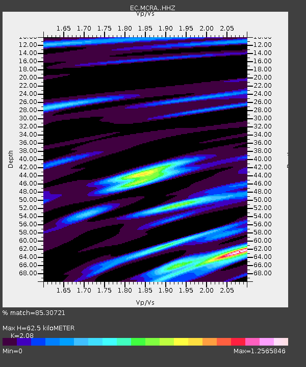
| Estimated Moho Depth: |
62.5 km |
| Estimated Crust Vp/Vs: |
2.08 |
| Assumed Crust Vp: |
6.35 km/s |
| Estimated Crust Vs: |
3.053 km/s |
| Estimated Crust Poisson's Ratio: |
0.35 |
|
| Radial Match: |
85.30721 % |
| Radial Bump: |
400 |
| Transverse Match: |
51.053 % |
| Transverse Bump: |
400 |
| SOD ConfigId: |
13570011 |
| Insert Time: |
2019-04-29 14:36:38.462 +0000 |
| GWidth: |
2.5 |
| Max Bumps: |
400 |
| Tol: |
0.001 |
|

Signal To Noise
| Channel | StoN | STA | LTA |
| EC:MCRA: :HHZ:20180119T16:25:12.208Z | 2.695115 | 1.9759563E-7 | 7.331621E-8 |
| EC:MCRA: :HHN:20180119T16:25:12.208Z | 0.9073325 | 8.3854374E-8 | 9.2418574E-8 |
| EC:MCRA: :HHE:20180119T16:25:12.208Z | 0.7899264 | 1.3377552E-7 | 1.6935186E-7 |
| Arrivals |
| Ps | 11 SECOND |
| PpPs | 29 SECOND |
| PsPs/PpSs | 40 SECOND |


